Devil Island
| Devil Island | |
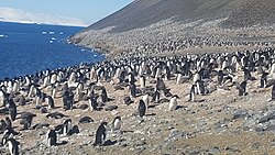
 Penguins on Devil Island | |
|---|---|
| Location | |
| Location: | 63°47’57"S, 57°17’20"W |
| Area: | 69 acres |
| Highest point: | height=492 feet |
| Data | |
Devil Island lies off the north coast of Vega Island in the James Ross Island Group, a group of islands lying off the north tip of Graham Land in the British Antarctic Territory.
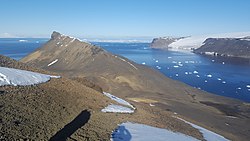
This is an ice-free island, of 69 acres, and lies in a small cove half a mile off the north coast of Vega Island. It is characterised by several low hills rising to a maximum height of about 492 feet.
Devil Island is a recent volcano, consisting of two basalt volcano necks, surrounded by extensive talus.

Exploration
The island was mapped by Nordenskjöld's Swedish Antarctic Expedition on 12 October 1903, and named Djävulsön, meaning "Devil's Island", from its inhospitable appearance
The island was resurveyed by the Falkland Islands Dependencies Survey from "Hope Bay" in 1945.
Outside links
| ("Wikimedia Commons" has material about Devil Island) |
- Gazetteer and Map of The British Antarctic Territory: Devil Island