Blaengwrach
| Blaengwrach | |
| Glamorgan | |
|---|---|

| |
| Location | |
| Grid reference: | SN868052 |
| Location: | 51°44’3"N, 3°38’26"W |
| Data | |
| Population: | 1,989 (2011) |
| Post town: | Port Talbot |
| Postcode: | SA11 |
| Dialling code: | 01639 |
| Local Government | |
| Council: | Neath Port Talbot |
| Parliamentary constituency: |
Neath |
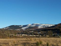
Blaengwrach is a village near Glynneath in Glamorgan.
It is a predominantly upland area, and contains the highest points of three local hills or mountains, namely Mynydd Resolfen (1,257 ft) and the rather more impressive Mynydd Pen-y-Cae (1,880 ft) and Craig-y-Llyn (1,969 ft), both of which offer spectacular views of the valley below and the Brecon Beacons in the distance. Craig-y-Llyn is the county top of Glamorgan, and is home to a nature reserve containing Llyn Fach and a Site of Special Scientific Interest. West of the summit is Foel Chwern Round cairn.
The village of Blaengwrach is often confused with the settlement of Cwmgwrach. Traditionally, the two are settlements separated by a stream or brook running through the middle of them. However, the sign welcoming you to Cwmgwrach is actually in Blaengwrach, and in similar fashion, Blaengwrach school is actually in Cwmgwrach. In reality the residents call the entire village Cwmgwrach, with Blaengwrach being best used as the name for the wider area in which the village is situated. A history of the village (Cwmgwrach: Valley of the Witch) was written by Ian Currie.
The village contains various local shops, pubs and a rugby union club, Cwmgwrach RFC. However, for wider services the village is largely dependent upon Glynneath.
The Neath and Tennant Canal has been restored and now has over four miles of walkable towpath between Resolven and Glynneath. The Vale of Neath Railway is still used for freight transport between Neath and Cwmgwrach.