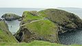
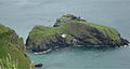
Carrick-a-Rede

Carrick-a-Rede or Carrickarede is an island on the wild, rocky north coast of County Antrim near Ballintoy, an island separated from the mainland cliffs by a deep chasm at the foot of which the sea washes in a narrow channel. The island is best known for the bridge which crosses the chasm form mainland to island; the Carrick-a-Rede Rope Bridge.
The island's name is from the old Gaelic Carraig a' Ráid, meaning "rock of the casting".
The bridge
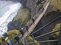
The Carrick-a-Rede Rope Bridge is a famous rope suspension bridge which links the cliffs of the Antrim mainland to the tiny island of Carrickarede. It spans 66 ft and is 100 ft above the rocks below.[1] The bridge is mainly a tourist attraction and is owned and maintained by the National Trust. In 2009 it had 247,000 visitors. The bridge is open all year round (subject to weather) and people may cross it for a fee.
History
It is thought salmon fishermen have been building bridges to the island for over 350 years. It has taken many forms over the years. In the 1970s it had only one handrail and large gaps between the slats. A new bridge, tested up to ten tons, was built with the help of local climbers and abseilers in 2000. Another was built in 2004 and offered visitors and fishermen alike a much safer passage to the island. The current wire rope and Douglas fir bridge was made by Heyn Construction in Belfast and raised early in 2008 at a cost of over £16,000.[2] Although no one has fallen off the bridge, there have been many instances where visitors, unable to face the walk back across the bridge, have had to be taken off the island by boat.
Fishing
It is no longer used by fishermen during the salmon season, which used to last from June until September, as there are now very few salmon left. In the 1960s, almost 300 fish were caught each day, but by 2002, only 300 were caught over the whole season. The salmon come through the area to spawn in the River Bann and the River Bush.
Features
The area is exceptional in natural beauty with stunning views of Rathlin Island and Argyll. The site and surrounding area is designated an Area of Special Scientific Interest for its unique geology, flora, and fauna. Underneath there are large caves, which once served as home for boat builders and as shelter during stormy weather.
Geology
Carrickarede island is the best example of a volcanic plug in Ulster. Marine erosion has exposed a section through the neck of this old volcano.[3]
The presence of tuff, explosion breccias, grey volcanic ash and explosion bombs show the extreme violence of the eruptions about 60 million years ago when molten rock punched its way through chalk.[4]
Along the coast of this area, as with much of the Antrim plateau, the cliffs are of basalt with the characteristic Ulster chalk underneath. At Carrickarede, the ancient volcanic pipe has left dolerite, a tougher rock than basalt, which erodes more slowly. Behind the dolerite, to the south, the vent is filled with pyroclastic rocks that break down more easily, mostly a coarse tuff agglomerate. The combination of the hard rock out front and the softer rock behind, with long term erosion by the waves, has eventually left this small island.[3]
Pictures
-
 Bridge in use 2010
 -
 Bridge structure, 2004
 -
 Bridge structure, 2005
 -
 Carrick-a-Rede Rope Bridge, 2007
 -
 Carrick-a-Rede Rope Bridge, 2007
 -
 Birds at Carrick-a-Rede, 2005
 -
 Carrick-a-Rede Rope Bridge, 2007


Outside links
| ("Wikimedia Commons" has material about Carrick-a-Rede) |
- Location map: 5°14’24"N, 6°19’52"W
- Carrick-a-Rede – National Trust
- Virtual tour of Carrick-a-Rede Rope Bridge
- New Rope Bridge for Carrick-a-Rede. CultureNorthernIreland.org Feature
References
- ↑ "Carrick-a-Rede". http://www.carrick-a-rederopebridge.com. Retrieved 2007-08-23.
- ↑ "New Rope Bridge For Carrick-a-Rede". http://www.culturenorthernireland.org/article.aspx?art_id=61. Retrieved 2008-05-30.
- ↑ 3.0 3.1 Habitas, Earth Science Conservation Review, National Museums Northern Ireland, Ballintoy - Ballycastle
- ↑ Habitas, Earth Science Conservation Review, National Museums Northern Ireland, Ballintoy - Ballycastle (summary)