Belton, Kesteven
- Not to be confused with Belton, Lindsey
| Belton | |
| Lincolnshire | |
|---|---|
 Mediæval Almshouse in Belton | |
| Location | |
| Grid reference: | SK930396 |
| Location: | 52°56’47"N, -0°36’60"W |
| Data | |
| Postcode: | NG32 |
| Dialling code: | 01476 |
| Local Government | |
| Council: | South Kesteven |
| Parliamentary constituency: |
Grantham and Stamford |
Belton is a village and ancient parish in Kesteven, Lincolnshire. It is situated on the A607 road, three miles north of the market town of Grantham. It forms part of the civil parish of Belton and Manthorpe.
History
The Saxon meaning of Belton is "a bell-shaped hollow".
The village is significant for the 1686 Grade I-listed Belton House.[1][2] The house is the property of the National Trust and is open to the public.[3]
A Belton church is recorded in the Domesday Book. The parish church of St Peter and St Paul is significant for its Norman, late Mediæval, Georgian and Victorian alterations and additions.[4]
In May 1643 Parliamentary cavalry, under the leadership of Oliver Cromwell, clashed with Royalist forces at the south of Belton Park, to the east of Manthorpe. The Belton church register records "May 1643, buried three unknown soldiers, slain in Belton fight".[5]
Community
Belton comprises thirty-one predominantly stone-built houses, most standing within a defined Conservation Area, with a further twelve homes outlying the village centre.
The village is part of the ecclesiastical parish of Belton. The church is dedicated to Saints Peter and Paul, and is part of the Loveden Deanery of the Diocese of Lincoln. The 2014 incumbent is Rev Stuart Hadley.[6]
Businesses in the village include a hotel with golf course, a farm equipment dealer, an auto parts manufacturer and a garden centre.
Belton is bypassed by the A607, a road which links Grantham to the south, and Lincoln to the north.
-
 Church of St Peter and St Paul from Belton Park
 -
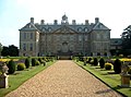 Belton House


References
- ↑ "Belton House", English Heritage. Retrieved 28 June 2011
- ↑ "National Monument record for Belton house.". http://www.pastscape.org.uk/hob.aspx?hob_id=325657. See also the 'related monuments'
- ↑ "National Trust web site for Belton House". http://www.nationaltrust.org.uk/main/w-beltonhouse.
- ↑ "National Monument record for the church". http://www.pastscape.org.uk/hob.aspx?hob_id=325654.
- ↑ "National Monument record for 'Alleged' battle site". http://www.pastscape.org.uk/hob.aspx?hob_id=325663.
- ↑ "Ecclesiastical parish Details". http://www.lincoln.anglican.org/search_parishes.php?23093010.
Outside links
| ("Wikimedia Commons" has material about Belton, Kesteven) |
- Belton Parish web site. Retrieved 28 June 2011
- Belton Church
- Belton village. Retrieved 18 Dec 2010
- Belton Tower. Retrieved 18 Dec 2010