Beighton
| Beighton | |
| Derbyshire | |
|---|---|
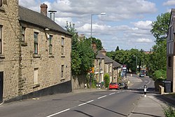
 Beighton High Street | |
| Location | |
| Grid reference: | SK440835 |
| Location: | 53°20’47"N, 1°20’26"W |
| Data | |
| Post town: | Sheffield |
| Postcode: | S20 |
| Dialling code: | 0114 |
| Local Government | |
| Council: | Sheffield |
| Parliamentary constituency: |
Sheffield South East |
Beighton is a village in north-east Derbyshire that forms a suburb of Sheffield after much expansion from a village in the last 100 years. The village was mentioned three times in the Domesday Book of 1086 as Bectun[1]—the name meaning a farmstead beside a stream (or beck). Some remnants of the old village have survived including the church of Saint Mary the Virgin, which was built in the 12th century. The population in 1931 was 5,553.
Being primarily a coal mining area, many of the houses erected in the first part of the 20th century were by the National Coal Board. Later expansion in the last 30 years has been in private housing.
The Rother Valley Country Park is just outside the eastern edge of the village and is a local centre for water sports. A number of artificial lakes have been created for this purpose.
Beighton railway station on the Great Central Main Line was closed in 1954.
The parish church St Mary the Virgin was restored in 1868 and a clock was erected in the tower in 1921 as a memorial to parishioners who gave their lives in the Great War.
Beighton Miners Welfare F.C. and Beighton Recreation F.C. both represented the area in the FA Cup.
References
- ↑ Domesday Book: A Complete Translation. London: Penguin, 2003. ISBN 0-14-143994-7 p.1313
| ("Wikimedia Commons" has material about Yorkshire Beighton) |
This Derbyshire article is a stub: help to improve Wikishire by building it up.