Abbey Wood
| Abbey Wood | |
| Kent | |
|---|---|
 Aerial view of Abbey Wood | |
| Location | |
| Grid reference: | TQ465785 |
| Location: | 51°29’11"N, -0°6’39"E |
| Data | |
| Population: | 17,700 (2021) |
| Post town: | London |
| Postcode: | SE2 |
| Dialling code: | 020 |
| Local Government | |
| Council: | Greenwich, Bexley |
| Parliamentary constituency: |
Erith and Thamesmead |
Abbey Wood is a suburban village in north-western Kent. According to the 2021 census, Abbey Wood has a population of about 17,700.
The area takes its name from Lesnes Abbey Woods, located to the east, which once belonged to the monks of Lesnes Abbey.[1]
Hisotry and development
Lesnes Abbey

The Abbey of St Mary and St Thomas the Martyr at Lesnes (or Lesnes Abbey) was founded in 1178 by Richard de Luci, Chief Justiciar of England. The Abbot of Lesnes Abbey was an important local landlord, and took a leading part in draining the marshland. However, this and the cost of maintaining river embankments was one of the reasons given for the Abbey's chronic financial difficulties. It never became a large community, and was closed by Cardinal Wolsey in 1525, under a licence to suppress monasteries of less than seven inmates. It was one of the first monasteries to be closed after the Dissolution of the Monasteries in 1524, and the monastic buildings were all pulled down, except for the Abbot's Lodging. Henry Cooke acquired the site in 1541 and it eventually passed to Sir John Hippersley who salvaged building materials, before selling the property to Thomas Hawes of London in 1632. It was then bequeathed to Christ's Hospital in 1633.
Railway Station
Abbey Wood railway station was opened in 1849, immediately to the north of the area now known as "The Village", built where Knee Hill became Harrow Manorway. Contemporary maps show Knee Hill as a minor track compared with a more major pathway through the centre of the existing woods.[2] The Village consisted of a dozen or so cottages, and two pubs, the Abbey Arms (next to the railway station) and the Harrow Inn (demolished in 2009).[3] The Harrow Inn, which was located outside the metropolitan part of Abbey Wood, was the place where live bands would play in their hall; it was also the scene of a nightly migration as drinkers would relocate to the Abbey Arms each night, as it was under the Kent magistrates who imposed closing times used to be 10.30 pm, whilst the Abbey Arms, which was under the London magistrates, closed at 11 o'clock.
Abbey Wood was suggested as a site for a cemetery serving east London at a time of burial crisis in the capital. When the station was new, Edwin Chadwick proposed the closure of all existing burial grounds in the vicinity of London other than the privately owned Kensal Green Cemetery in Middlesex, north-west of the city, which was to be nationalised and greatly enlarged to provide a single burial ground for west London, while a large tract of land on the Thames around nine miles south-east of London in Abbey Wood was to become a single burial ground for the east of the metropolis.[4] The Treasury was sceptical that Chadwick's scheme would ever be financially viable, and it was widely unpopular.[5][6] Although the Metropolitan Interments Act 1850 (13 & 14 Vict. c. 52) authorised the scheme, it was abandoned in 1852.[6]
The Co-op Estate
The Royal Arsenal Co-operative Society (RACS) owned two farms on the hillside to the south of The Village; between 1900 and 1930, the RACS built the Bostall Estate, designed by architect Frank Bethell. Once known as "Tin Check Island" after the Society's dividend system, and known locally as "The Co-op Estate", this has streets named after Co-operative themes (Alexander McLeod, the first secretary of the RACS, Rochdale, Robert Owen, Congress), a school and shops but, like much social housing of the period, no public houses. The housing is largely traditional of the "two-up, two-down" design, in distinctive yellow London brick, with gardens to the front and rear.[7] A description of the innovative construction processes used to construct the houses 'in a thoroughly substantial manor' is detailed here, which included digging a chalk mine locally for plaster. This mine was subsequently used as a bomb shelter in First World War.[8]

Between 1955 and 1959, the council built the Abbey Estate starting with one road south of the railway and later extending on the northern side on former Royal Arsenal marshland. Predominantly conventional brick houses with gardens, at first there were no shops or pubs, later equipped with a few shops and pubs together with schools and open spaces were added. Transport was non-existent at first until one bus, the route 180 was added after the building of Eynsham bridge. The estate was first used to rehouse people from Dockhead and Peckham then London's East End. The main through-road is Eynsham Drive.
Thamesmead
In the mid-1960s, the council began building the first phase of Thamesmead on more ex-Royal Arsenal land, north-east of Abbey Wood station. When it was initially developed, Thamesmead was envisioned as a revolutionary 'city within a city' of 60,000 people, providing much needed affordable homes with suitable amenities, surrounded by a lake and landscaped parkland exploiting it's riverside position. It was designed in keeping with the emerging 'Brutalist' aesthetic.[9] Despite being the culmination of that council's housing works, ultimately only stages 1 and 2 were completed, and the master plan was only partially realised.[10]

Elizabeth Line
Abbey Wood station is the south-east terminus for the Elizabeth line, which opened in 2022, with direct travel times of 11 minutes to Canary Wharf and 25 minutes to Bond Street. The distinctive new station has transformed the area, resolving complex urban design issues and delivering a seamless multi modal interchange.[11] A decade after work began on the line, Abbey Wood has seen the strongest price growth across London, at 107% over ten years.[12] Property prices have more than doubled over the past decade in the local areas around Abbey Wood station, with Abbey Wood seen as a 'buyer competition hotspot', with a +869% increase in buyer competition compared to ten years ago.[13]
About the village


Places of interest include the ruins of the 12th-century Lesnes Abbey and the adjacent Lesnes Abbey Woods, a Local Nature Reserve. Part of the Woods are designated as a 'Site of Special Scientific Interest' called Abbey Wood, which has important Paleogene fossils. The ancient Bostall Woods & Heath are part of the South East London Green Chain - a 40 mile, signposted network of footpaths link together many of the finest open spaces in north-western Kent.[14] This area includes one of the few camping and caravan sites in London, which is owned and operated by The Caravan Club. The co-operative woods were also the site of the first camp for the Woodcraft Folk.
St Michael and All Angels Parish Church was opened in a temporary building in 1905. A permanent church, designed by Sir Arthur Blomfield, was consecrated three years later, and the original building became the church hall. The 'Grade I' listed Victorian Crossness Pumping Station is described by architectural historian Nikolaus Pevsner as "a masterpiece of engineering – a Victorian cathedral of ironwork".[15]
Media and culture
The Thamesmead estate was the focus of an exhibition at Royal Institute of British Architects to mark its 50th anniversary. "Thamesmead: A Town for the 21st Century" presented a series of archival images of Thamesmead, displayed alongside contemporary photographs of the estate’s residents. The buildings have been utilised as a backdrop for many filmic projects, including the Stanley Kubrick film A Clockwork Orange.
The Lakeside Centre, situated on the edge of Southmere Lake, is home to a growing creative community, with 38 affordable artist studios, two artist in residence studios, a community darkroom and community garden.[16]
Pictures
| ("Wikimedia Commons" has material about Abbey Wood) |
-
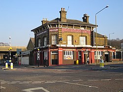 The Harrow Inn, demolished in 2009.
 -
 Ruins of Lesnes Abbey
 -
 Past Lesnes Abbey to Lesnes Abbey Woods
 -
 Data Tree sculpture in the woods
 -
 Lesnes Abbey Woods heathland'


.jpg)

References
- ↑ Mills, A.D. (2010). A Dictionary of London Place-Names. Oxford University Press. p. 1. ISBN 9780199566785.
- ↑ See http://www.ideal-homes.org.uk/greenwich/abbey-wood/map-abbey-wood-1870.htm Template:Webarchive.
- ↑ See http://www.stmichaelsabbeywood.co.uk/history.htm
- ↑ Clarke, John M. (2006). The Brookwood Necropolist Railway, Locomotive Papers 143 (4th edn). The Orchard Press. p. 8. ISBN 978-0-85361-655-9.
- ↑ Arnold, Catherine (2006). Necropolis: London and its dead. Simon & Schuster. p. 160. ISBN 978-1-4165-0248-7.
- ↑ 6.0 6.1 The Brookwood Necropolis Railway. p. 11.
- ↑ See http://www.kentarchaeology.ac/authors/006.pdf for a more detailed description of the building of the Bostall Estate.
- ↑ "The Royal Arsenal Co-operative Society’s Chalk Mine and the Building of the Bostall Estate" (in en-GB). https://www.kentarchaeology.org.uk/papers/the-royal-arsenal-co-operative-societys-chalk-mine.
- ↑ Ray, Debika (2020-04-08). "A brief history of Brutalist social estate Thamesmead" (in en-GB). https://www.iconeye.com/architecture/a-brief-history-of-brutalist-social-estate-thamesmead.
- ↑ "Thamesmead | RIBA pix". https://www.ribapix.com/thamesmead.
- ↑ Fereday Pollard (2022). "Abbey Wood Station". https://www.feredaypollard.com/projects/crossrail-abbey-wood-station.
- ↑ Bloomfield, Ruth (2022-06-01). "The Elizabeth line stops with greatest house price growth" (in en). https://www.standard.co.uk/homesandproperty/property-news/crossrail-property-hotspots-elizabeth-line-house-price-growth-b1002109.html.
- ↑ Jenkins, Steve (2022-05-25). "Property prices double around Elizabeth Line stations" (in en-US). https://hub.rightmove.co.uk/property-prices-double-around-elizabeth-line-stations/.
- ↑ "Green Chain Walk (TFL Website)" (in en-GB). https://tfl.gov.uk/modes/walking/green-chain-walk.
- ↑ "Historic England List". https://historicengland.org.uk/listing/the-list/list-entry/1064241?section=official-list-entry.
- ↑ "Lakeside Centre" (in en-GB). https://www.thamesmeadnow.org.uk/explore/arts-culture/lakeside-centre/.