Difference between revisions of "Woodspeen"
From Wikishire
m |
|||
| Line 14: | Line 14: | ||
|constituency= | |constituency= | ||
}} | }} | ||
| − | '''Woodspeen''' is a village in [[Berkshire]], close to [[Speen, Berkshire|Speen]], from which it tales its name, and part of that parish | + | '''Woodspeen''' is a village in [[Berkshire]], close to [[Speen, Berkshire|Speen]], from which it tales its name, and part of that parish. |
| − | The | + | The village stands near to the A34 road (the Newbury Bypass), approximately 2½ miles north-west of [[Newbury]]. |
==Outside links== | ==Outside links== | ||
Latest revision as of 19:30, 19 July 2023
| Woodspeen | |
| Berkshire | |
|---|---|
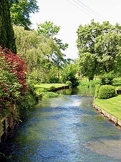
 The River Lambourn at Woodspeen | |
| Location | |
| Grid reference: | SU446693 |
| Location: | 51°25’14"N, 1°21’45"W |
| Data | |
| Post town: | Newbury |
| Postcode: | RG14 |
| Dialling code: | 01635 |
| Local Government | |
| Council: | West Berkshire |
Woodspeen is a village in Berkshire, close to Speen, from which it tales its name, and part of that parish.
The village stands near to the A34 road (the Newbury Bypass), approximately 2½ miles north-west of Newbury.
Outside links
| ("Wikimedia Commons" has material about Woodspeen) |