West Woodburn
| West Woodburn | |
| Northumberland | |
|---|---|
 West Woodburn | |
| Location | |
| Grid reference: | NY895865 |
| Location: | 55°10’23"N, 2°9’58"W |
| Data | |
| Post town: | Hexham |
| Postcode: | NE48 |
| Dialling code: | 01434 |
| Local Government | |
| Council: | Northumberland |
| Parliamentary constituency: |
Hexham |
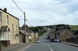
West Woodburn is a village in north-western Northumberland. It is allotted to the Parish of Corsenside of which West Woodburn is the main settlement. The 2001 census recorded a population of 492 in the whole parish.
The village is to be found thirteen miles north of Hexham and fifteen miles south of the Roxburghshire boundary.
West Woodburn lies on the line of Dere Street, a Roman road which forged its way north of the Roman frontier, linking Eboracum (York) to the Firth of Forth. To the west of West Woodburn are the remains of a Roman fort known as Habitancum. The route is now the A68 road.
The River Rede, a major tributary of the River North Tyne, flows through the heart of the village.
The border collie was first bred by a West Woodburn man, Adam Telfer. Telfer was a shepherd who lived in the village circa 1893 and herded sheep with and his sheepdog 'Old Hemp', and developed the border collie breed for these hills. A memorial to Telfer and Hemp has been erected in the village.
Outside links
| ("Wikimedia Commons" has material about West Woodburn) |
