West Perry
| Perry | |
| Huntingdonshire | |
|---|---|
 West Perry, Huntingdonshire | |
| Location | |
| Grid reference: | TL148669 |
| Location: | 52°17’21"N, 0°19’2"W |
| Data | |
| Postcode: | PE28 |
| Local Government | |
| Council: | Huntingdonshire |
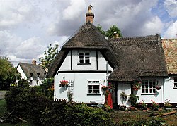
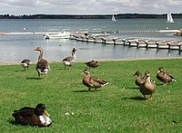
West Perry is a small village in Huntingdonshire, sitting on the southern shore of Grafham Water, a large man-made lake or reservoir in the west of the county. Facing it across the water is Grafham, Huntingdonshire. The village is the site of the visitor centre for Grafham Water.
West Perry is just a few miles from the market towns of St Neots and Huntingdon. Just along the road to the east is the hamlet of East Perry.
East and West Perry were once in two separate parishes; West Perry with Great Staughton) and East Perry with Grafham. The Church has since recognised the great gulf between Grafham and East Perry though, namely Grafham Water, and both are within the care of St Andrew's, Great Staughton.
In the village there is a village shop, a pub (The Wheatsheaf), a watersport activity centre, a restaurant and conference suite.
The village also includes HMP Littlehey, built on the site of former borstal Gaynes Hall.
East Perry
East Perry is a minor hamlet strung along the road to the east of West Perry; most of its ancient acres must now be beneath the waters. East and West Perry may together be known just as "Perry".
Outside links
| ("Wikimedia Commons" has material about West Perry) |
