Difference between revisions of "West Knoyle"
From Wikishire
(Created page with "{{infobox town |county=Hants |picture= Telephone box, West Knoyle - geograph.org.uk - 1145254.jpg |picture caption= Telephone box, West Knoyle |latitude= 51.092 |longitude= -...") |
|||
| Line 1: | Line 1: | ||
{{infobox town | {{infobox town | ||
| − | |county= | + | |county=Wilts |
|picture= Telephone box, West Knoyle - geograph.org.uk - 1145254.jpg | |picture= Telephone box, West Knoyle - geograph.org.uk - 1145254.jpg | ||
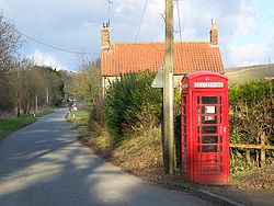
|picture caption= Telephone box, West Knoyle | |picture caption= Telephone box, West Knoyle | ||
| Line 15: | Line 15: | ||
|website= [http://www.westknoyle.co.uk/ West Knoyle] | |website= [http://www.westknoyle.co.uk/ West Knoyle] | ||
}} | }} | ||
| − | '''West Knoyle''' is a small village and parish in south-west [[Wiltshire]], close to the southern edge of [[Salisbury Plain]]. The village is about 2½ miles east of [[Mere, Wiltshire|Mere]] | + | '''West Knoyle''' is a small village and parish in south-west [[Wiltshire]], close to the southern edge of [[Salisbury Plain]]. The village is eight miles south of [[Warminster]] and about 2½ miles east of [[Mere, Wiltshire|Mere]] in the [[Mere Hundred]]. The A303 trunk road passes about ¾ mile north of the village. The parish was formerly named Knoyle Hodierne, after Hodierna of St Albans, wet nurse of Richard I, who had an estate at [[Chippenham]].<ref>{{Cite book| publisher = Longmans, Green, Reader, and Dyer| others = William Stubbs (ed.)| title = Chronica magistri Rogeri de Houedene| location = London| series = Rolls Series| page = xviii}}</ref> |
The [[Church of England|Anglican]] Church of St Mary the Virgin is Grade II* listed.<ref>{{National Heritage List for England|num=1199597|desc=Church of St Mary the Virgin, West Knoyle|access-date=17 June 2015}}</ref> It has 13th-century origins and was restored in 1876-78. | The [[Church of England|Anglican]] Church of St Mary the Virgin is Grade II* listed.<ref>{{National Heritage List for England|num=1199597|desc=Church of St Mary the Virgin, West Knoyle|access-date=17 June 2015}}</ref> It has 13th-century origins and was restored in 1876-78. | ||
Latest revision as of 15:01, 9 January 2020
| West Knoyle | |
| Wiltshire | |
|---|---|
 Telephone box, West Knoyle | |
| Location | |
| Grid reference: | ST858325 |
| Location: | 51°5’31"N, 2°12’14"W |
| Data | |
| Population: | 146 (2011[1]) |
| Post town: | Warminster |
| Postcode: | BA12 |
| Dialling code: | 01747 |
| Local Government | |
| Council: | Wiltshire |
| Parliamentary constituency: |
South West Wiltshire |
| Website: | West Knoyle |
West Knoyle is a small village and parish in south-west Wiltshire, close to the southern edge of Salisbury Plain. The village is eight miles south of Warminster and about 2½ miles east of Mere in the Mere Hundred. The A303 trunk road passes about ¾ mile north of the village. The parish was formerly named Knoyle Hodierne, after Hodierna of St Albans, wet nurse of Richard I, who had an estate at Chippenham.[2]
The Anglican Church of St Mary the Virgin is Grade II* listed.[3] It has 13th-century origins and was restored in 1876-78.
The Monarch's Way long-distance footpath passes through the village. Hang Wood, to the south-east, is a biological Site of Special Scientific Interest.
References
- ↑ "Wiltshire Community History - Census". Wiltshire Council. http://history.wiltshire.gov.uk/community/getcensus.php?item=West%20Knoyle. Retrieved 17 June 2015.
- ↑ Chronica magistri Rogeri de Houedene. Rolls Series. William Stubbs (ed.). London: Longmans, Green, Reader, and Dyer. p. xviii.
- ↑ National Heritage List 1199597: Church of St Mary the Virgin, West Knoyle
Outside links
- "West Knoyle village site". http://www.westknoyle.co.uk/. Retrieved 17 June 2015.
| ("Wikimedia Commons" has material about West Knoyle) |