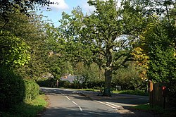
Wellington Heath
From Wikishire
Revision as of 12:24, 17 September 2019 by RB (Talk | contribs) (Created page with "{{Infobox town |name=Wellington Heath |county=Herefordshire |picture=Road junction, Wellington Heath - geograph.org.uk - 964489.jpg |picture caption= |os grid ref=SO710401 |la...")
| Wellington Heath | |
| Herefordshire | |
|---|---|

| |
| Location | |
| Grid reference: | SO710401 |
| Location: | 52°3’32"N, 2°25’23"W |
| Data | |
| Population: | 440 |
| Post town: | Ledbury |
| Postcode: | HR8 |
| Dialling code: | 01531 |
| Local Government | |
| Council: | Herefordshire |
| Parliamentary constituency: |
North Herefordshire |
Wellington Heath is a small village in Herefordshire, about a mile and a half to the north of Ledbury.
The population was recorded by the 2011 census at 440.
The village contains a church, Christ Church, Wellington Heath.[1]
There is a public house, the "Farmers Arms".[2]
The Herefordshire Trail long-distance footpath passes through the village, as does The National Byway.
The route of the derelict Herefordshire and Gloucestershire Canal passes through the western part of the parish.
Outside links
| ("Wikimedia Commons" has material about Wellington Heath) |
References
- ↑ "Christ Church, Wellington Heath". Church of England. http://www.achurchnearyou.com/wellington-heath-christ-church/. Retrieved 6 February 2016.
- ↑ CAMRA WhatPub