Difference between revisions of "Template:Todaysimage"

From Wikishire
Jump to: navigation, search
 
(11 intermediate revisions by 3 users not shown)
Line 1: Line 1:
'''This month's image''' is:
+
{{clear}}
 +
'''Today's featured image''' is:
  
[[File:{{#switch:{{CURRENTMONTH}}
+
{|
| 08=Dubbyhole Upper Townland - geograph.org.uk - 258443.jpg{{!}}Dubbyhole, [[County Londonderry|Co Londonderry]]
+
|- align="left" valign="top"
| 09=Abingdon Berks St Helens.jpg{{!}}[[Abingdon]] from the Thames
+
|[[File:{{FP-{{pickday}}|pic}}|left|thumb|300px|{{FP-{{pickday}}|cap}}]]
| 10= Caerleon Amphitheatre.jpg{{!}}Roman Amphitheatre at [[Caeleon]], Monmouthshire
+
|
| 11= Swale River at Richmond 01.JPG{{!}}The River Swale, near [[Richmond, Yorkshire]]
+
=={{pickday}}==  
|}}|left|thumb|300px]]
+
{{FP-{{pickday}}|text}} ([[{{pickday}}|Read more]])''
 
+
|}<noinclude>[[Category:Front Page templates]]
=={{#switch:{{CURRENTMONTH}}
+
| 08=Dubbyhole
+
| 09=Abingdon
+
| 10=Caerleon
+
| 11= River Swale
+
|}}==  
+
{{#switch:{{CURRENTMONTH}}
+
| 08='''Dubbyhole''' is a townland in [[Couty Londonderry]].
+
| 09='''Abingdon''' (or Abingdon-on-Thames) is a market town in [[Berkshire]], of which county it is the county town. Abingdon is one of several places that claim to be Britain's oldest continuously-occupied town, with people having lived there for at least 6,000 years.
+
 
+
Abingdon lies 5½ miles south of Oxford and five miles north of Didcot, in the flat valley of the Thames and is situated on the west (right) bank of that river, where the river Ock flows in from the Vale of White Horse. ''([[Abingdon|Read more]])''
+
| 10='''Caerleon''' is a village in [[Monmouthshire]].  It is best known as the site of a Roman town and fortress, ''Venta Silurium'', whose remains have been excavated and are now in the care of CADW.
+
| 11= '''Richmond''' is a town in the [[North Riding of Yorkshire]].  The town was named after the Norman Conquest when it and the surounding lands were granted by William the Conqueror to a Breton nobleman.  It became the centre of a Liberty known as "Richmondshire".
+
|}}
+

Latest revision as of 22:06, 12 December 2014

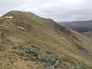
Today's featured image is:

St Sunday Crag, Westmorland

St Sunday Crag

St Sunday Crag is a fell in Westmorland, in the Lake District. It is part of the Fairfield group in the Eastern Fells and is a prominent feature in the Patterdale skyline, with its distinctive rounded shape. Indeed, it figures so finely in views from the upper reach of the lake that it is sometimes referred to as 'the Ullswater Fell'. (Read more)