Difference between revisions of "Template:FP-Crossmaglen"
From Wikishire
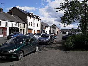
(Created page with "{{#switch:{{{1}}} |pic=Cardinal O'Fiach Square, Crossmaglen - geograph.org.uk - 1447342.jpg |cap=Cardinal O'Fiach Square, Crossmaglen, County Armagh |text='''Crossmaglen''' is...") |
|||
| Line 4: | Line 4: | ||
|text='''Crossmaglen''' is a village in the south of [[County Armagh]]. With a population of 1,592 at the 2011 Census it is the largest village in South Armagh. The name is of the village is from the Irish ''Crois Mhic Lionnáin'', meaning "Mac Lionnáin's cross". | |text='''Crossmaglen''' is a village in the south of [[County Armagh]]. With a population of 1,592 at the 2011 Census it is the largest village in South Armagh. The name is of the village is from the Irish ''Crois Mhic Lionnáin'', meaning "Mac Lionnáin's cross". | ||
| − | The town stands close by the border with the Republic of Ireland at a crossroads of four main routes, of which three come from across the border, which position shaped the face of the place during the Troubles.}}<noinclude>{{ | + | The town stands close by the border with the Republic of Ireland at a crossroads of four main routes, of which three come from across the border, which position shaped the face of the place during the Troubles.}}<noinclude>{{FP data}} |
| − | + | ||
| − | + | ||
Latest revision as of 09:18, 9 May 2021
CrossmaglenCrossmaglen is a village in the south of County Armagh. With a population of 1,592 at the 2011 Census it is the largest village in South Armagh. The name is of the village is from the Irish Crois Mhic Lionnáin, meaning "Mac Lionnáin's cross". The town stands close by the border with the Republic of Ireland at a crossroads of four main routes, of which three come from across the border, which position shaped the face of the place during the Troubles. (Read more) |
