Stocking Pelham
From Wikishire
Revision as of 23:05, 18 November 2012 by RB (Talk | contribs) (Created page with '{{Infobox town |name=Stocking Pelham |county=Hertfordshire |picture=St. Mary - the parish church of Stocking Pelham - geograph.org.uk - 1279639.jpg |picture caption=St. Mary's Ch…')
| Stocking Pelham | |
| Hertfordshire | |
|---|---|
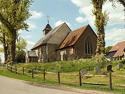
 St. Mary's Church, Stocking Pelham | |
| Location | |
| Grid reference: | TL4529 |
| Location: | 51°56’31"N, 0°6’43"E |
| Data | |
| Local Government | |
| Council: | East Hertfordshire |
Stocking Pelham is a village in eastern Hertfordshire. The village is one of the three Pelhams, along with the nearby Brent Pelham and Furneux Pelham.
The village has a church dedicated to Saint Mary, and once had a pub called The Cock, though this was destroyed by fire in February 2008.
Close by the village is a major electrical substation of the National Grid.
Outside links
| ("Wikimedia Commons" has material about Stocking Pelham) |