Difference between revisions of "Roberton"
(Created page with "{{Infobox town |name=Roberton |county 1=Selkirkshire |county 2=Roxburghshire |picture=Approaching Roberton along the A711 - geograph.org.uk - 2909211.jpg |picture caption=Robe...") |
|||
| Line 16: | Line 16: | ||
|LG district=Scottish Borders | |LG district=Scottish Borders | ||
}} | }} | ||
| − | '''Roberton''' is a small village in [[Selkirkshire]] adjacent to the border with [[Roxburghshire]]. Its parish extends across the border into the latter county. The village is situate on the B711 road and near to the A7, five miles from [[Hawick]], 22 miles from [[Galashiels]], and 23 miles from [[Langholm]]. It is situated by the [[Ale Water]], the [[Alemoor Loch]] and the [[Borthwick Water]], and nearby are [[Branxholme]], [[Broadhaugh]], Burnfoot and the [[Craik Forest]]. | + | '''Roberton''' is a small village in [[Selkirkshire]] adjacent to the border with [[Roxburghshire]]. Its parish extends across the border into the latter county and in fact the larger part lies in Roxburghshire, although the churchyard lies just on the Selkirkshire side of the border. The village is situate to the south of the churchyard on the B711 road and near to the A7, five miles from [[Hawick]], 22 miles from [[Galashiels]], and 23 miles from [[Langholm]]. It is situated by the [[Ale Water]], the [[Alemoor Loch]] and the [[Borthwick Water]], and nearby are [[Branxholme]], [[Broadhaugh]], Burnfoot and the [[Craik Forest]]. |
==Borders Poet== | ==Borders Poet== | ||
Latest revision as of 19:56, 15 May 2016
| Roberton | |
| Selkirkshire, Roxburghshire | |
|---|---|
 Roberton | |
| Location | |
| Grid reference: | NT430143 |
| Location: | 55°25’10"N, 2°54’2"W |
| Data | |
| Post town: | Hawick |
| Postcode: | TD9 |
| Dialling code: | 01450 |
| Local Government | |
| Council: | Scottish Borders |
| Parliamentary constituency: |
Berwickshire, Roxburgh and Selkirk |
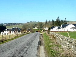
Roberton is a small village in Selkirkshire adjacent to the border with Roxburghshire. Its parish extends across the border into the latter county and in fact the larger part lies in Roxburghshire, although the churchyard lies just on the Selkirkshire side of the border. The village is situate to the south of the churchyard on the B711 road and near to the A7, five miles from Hawick, 22 miles from Galashiels, and 23 miles from Langholm. It is situated by the Ale Water, the Alemoor Loch and the Borthwick Water, and nearby are Branxholme, Broadhaugh, Burnfoot and the Craik Forest.
Borders Poet
The Borders poet William Henry Ogilvie was born in Kelso in 1869. A cairn has been erected in his memory. "The hill road to Roberton's a steep road to climb, But where your foot has crushed it, you can smell the scented thyme, And if your heart's a Border heart, look down to Harden Glen, And hear the blue hills ringing with the restless hoofs again...."[1]
Borthwick Mains Symbol Stone
Half-a-mile to the east of the village, in front of the house at Borthwick Mains, is a fish symbol-stone, possibly representing a salmon.[2] The stone is five feet high, and the figure of a fish is three feet long, with the tail downwards, cut into the stone with pecked lines.[2] It is similar to class 1 Pictish symbol stones of the 6th or 7th century, but its status is doubtful, and it may belong to a more recent period.[3]
Notes
- ↑ Southern Reporter, 27 August 2009: "Rightful honour restored to poet Will Ogilvie on Road to Roberton"
- ↑ 2.0 2.1 Borthwick Mains Carved Stone, RCHAMS
- ↑ Iain Fraser (2008) The Pictish symbol stones of Scotland, page 8. RCHAMS
References
- Brooke, CJ (2000) Safe sanctuaries: security and defence in Anglo-Scottish border churches 1290-1690, Edinburgh. Held at RCAHMS: F.5.31.BRO
- THAS (1963) 'Sculptured stone found at Roberton'.
Outside links
| ("Wikimedia Commons" has material about Roberton) |
- RCAHMS record of Roberton (Roxburghshire), sometimes known as Kirk Borthwick Parish
- Old Roads of Scotland: Craik Moor via Roberton to Hawick
- Roberton Primary School, presently the oldest school in the Scottish Borders
- GENUKI data on Roberton
- Incident at Roberton Water Treatment Works
- Flickr images of Hawick Common Riding, Roberton ride-out, 2009
This Selkirkshire article is a stub: help to improve Wikishire by building it up.