Difference between revisions of "River Clydach, Brecknockshire"
From Wikishire
| Line 1: | Line 1: | ||
{{county|Brecknockshire}} | {{county|Brecknockshire}} | ||
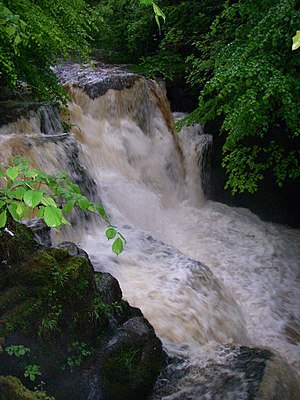
[[File:Afon Clydach, Rhaeadr Isaf - geograph.org.uk - 432611.jpg|thumb|right|The Clydach's Lower Waterfall]] | [[File:Afon Clydach, Rhaeadr Isaf - geograph.org.uk - 432611.jpg|thumb|right|The Clydach's Lower Waterfall]] | ||
| − | The '''River Clydach''' is a short, steep and fast-flowing river in [[Brecknockshire]]. It lies within the Brecon Beacons National Park. It is around six miles in length. | + | The '''River Clydach''' is a short, steep and fast-flowing river in [[Brecknockshire]]. It lies within the [[Brecon Beacons]] National Park. It is around six miles in length. |
| − | The river rises on the southern slopes of Llangattock Mountain ({{wmap|51.8122|-3.1939|zoom=14|name=River Clydach, source}}) then heads south-east through Clydach Dingle past [[Brynmawr]]. It then enters the spectacular Clydach Gorge, dropping about 1,000 ft to [[Gilwern]] and its confluence with the [[River Usk]] ({{wmap|51.8329|-3.1007|zoom=14|name=River Clydach, mouth}}).<ref>Ordnance Survey Explorer map OL13, "Brecon Beacons National Park: eastern area".</ref> | + | The river rises on the southern slopes of [[Llangattock Mountain]] ({{wmap|51.8122|-3.1939|zoom=14|name=River Clydach, source}}) then heads south-east through Clydach Dingle past [[Brynmawr]]. It then enters the spectacular [[Clydach Gorge]], dropping about 1,000 ft to [[Gilwern]] and its confluence with the [[River Usk]] ({{wmap|51.8329|-3.1007|zoom=14|name=River Clydach, mouth}}).<ref>Ordnance Survey Explorer map OL13, "Brecon Beacons National Park: eastern area".</ref> |
| − | "Clydach" is a common name for watercourses in south Wales and is thought to derive from an old Welsh language word for "swift" or possibly "stoney", both of which would apply in this case.<ref>Owen, H. W., & Morgan, R. (2007). ''Dictionary of the Place-names of Wales''. Gomer Press, Cardiganshire.</ref> | + | "Clydach" is a common name for watercourses in south Wales and is thought to derive from an old Welsh-language word for "swift" or possibly "stoney", both of which would apply in this case.<ref>Owen, H. W., & Morgan, R. (2007). ''Dictionary of the Place-names of Wales''. Gomer Press, Cardiganshire.</ref> |
== References == | == References == | ||
{{Reflist}} | {{Reflist}} | ||
[[Category:Rivers of Brecknockshire|Clydach]] | [[Category:Rivers of Brecknockshire|Clydach]] | ||
Latest revision as of 09:38, 16 October 2018
The River Clydach is a short, steep and fast-flowing river in Brecknockshire. It lies within the Brecon Beacons National Park. It is around six miles in length.
The river rises on the southern slopes of Llangattock Mountain (51°48’44"N, 3°11’38"W) then heads south-east through Clydach Dingle past Brynmawr. It then enters the spectacular Clydach Gorge, dropping about 1,000 ft to Gilwern and its confluence with the River Usk (51°49’58"N, 3°6’3"W).[1]
"Clydach" is a common name for watercourses in south Wales and is thought to derive from an old Welsh-language word for "swift" or possibly "stoney", both of which would apply in this case.[2]
