Difference between revisions of "Perth Bridge"
(Created page with "{{Infobox bridge |name=Perth Bridge |county=Perth |picture=Perth Tay Bridge.jpg |picture caption=looking across to Perth Bridge |os grid ref=NO12132388 |latitude=56.399 |longi...") |
(→Gallery) |
||
| Line 36: | Line 36: | ||
==Gallery== | ==Gallery== | ||
<gallery> | <gallery> | ||
| − | File:The imperial gazetteer of Scotland; or, Dictionary of Scottish topography, compiled from the most recent authorities, and forming a complete body of Scottish geography, physical, statistical, and (14595861428).jpg|The bridge | + | File:The imperial gazetteer of Scotland; or, Dictionary of Scottish topography, compiled from the most recent authorities, and forming a complete body of Scottish geography, physical, statistical, and (14595861428).jpg|The bridge before being widened in 1869 |
| − | File:St. Matthew's Church and Smeaton's Bridge.jpg|Smeaton's Bridge | + | File:St. Matthew's Church and Smeaton's Bridge.jpg|Smeaton's Bridge and St Matthew's Church |
| − | File:Plaque on Smeatons bridge.jpg|A plaque on the bridge | + | File:Plaque on Smeatons bridge.jpg|A plaque on the bridge |
| − | File:Perth Bridge from Bridgend.jpg| | + | File:Perth Bridge from Bridgend.jpg|From Bridgend's East Bridge Street to West Bridge Street |
| − | File:Commercial Street, Bridgend, Perth.jpg| | + | File:Commercial Street, Bridgend, Perth.jpg|Commercial Street in Bridgend, from the bridge |
</gallery> | </gallery> | ||
Latest revision as of 10:40, 8 November 2020
| Perth Bridge | |
| Perthshire | |
|---|---|
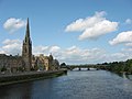
 looking across to Perth Bridge | |
| Location | |
| Carrying: | A85 road |
| Crossing: | River Tay |
| Location | |
| Grid reference: | NO12132388 |
| Location: | 56°23’56"N, 3°25’31"W |
| Structure | |
| Main span: | 714 feet |
| Design: | Arch |
| History | |
| Built 1771 | |
| Information | |
Perth Bridge (also known as Smeaton's Bridge, locally, the Old Bridge, is a Georgian road bridge in the City of Perth crossing the River Tay, in the heart of Perthshire. The bridge connects Perth, on the western side of the river, with Bridgend, on its eastern side, carrying both automotive and pedestrian traffic of West Bridge Street (the A85).
In its day, the Old Bridge, though far inland, was the lowest bridge of the river and so a vital point for transport, which was the reason for Perth's prosperity until the Victorian Age threw a railway bridge across the Firth of Tay.
The bridge is a Category A listed structure.[1]
Perth Bridge was completed in October 1771,[2][3] though its plaque states the year in which construction began, 1766, as its "built" date. The engineer of its construction was John Smeaton, after whom the bridge is named.
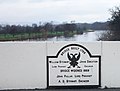
Funded by Thomas Hay, 9th Earl of Kinnoull, the government, and public subscription, the bridge was put to the test three years after its completion. In February 1774, during a quick thaw, broken ice became wedged under the arches and created a natural dam. Large sections of Perth, including both of its 'Inches', were flooded. The bridge, however, stood firm. It has survived many subsequent floods, and marks documenting these levels are visible on one of its piers.
An increase in traffic resulted in the bridge being widened in 1869 by A.D. Stewart. Its stone parapets were removed, and footpaths projected over iron brackets.
Gallery

The bridge before being widened in 1869
Smeaton's Bridge and St Matthew's Church
A plaque on the bridge

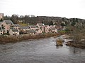
From Bridgend's East Bridge Street to West Bridge Street
Commercial Street in Bridgend, from the bridge
.jpg)


Outside links
References
- ↑ Perth Bridge Over River Tay (Category A) - Listing detail (Historic Environment Scotland)
- ↑ Perth and Kinross Council website - Lottery Levity 2
- ↑ EngineeringTimelines.com
| Bridges and crossings on the River Tay | ||||||
|---|---|---|---|---|---|---|
| Caputh Bridge | Kinclaven Bridge | Cargill Viaduct | Perth Bridge | Queen's Bridge | West Railway Bridge | Friarton Bridge |