Difference between revisions of "Penbryn"
From Wikishire
(→Notes) |
|||
| Line 7: | Line 7: | ||
|latitude=52.13988 | |latitude=52.13988 | ||
|longitude=-4.49436 | |longitude=-4.49436 | ||
| − | |post town= | + | |post town=Llandysul |
|postcode=SA44 | |postcode=SA44 | ||
| − | |dialling code= | + | |dialling code=01239 |
|population= | |population= | ||
|LG district=Ceredigion | |LG district=Ceredigion | ||
|constituency=Ceredigion | |constituency=Ceredigion | ||
}} | }} | ||
| − | '''Penbryn''' is a tiny village with a | + | '''Penbryn''' is a tiny village with a long, sandy beach on the coast of [[Cardiganshire]], some ten miles up the coast from [[Cardigan]]. It sits between the villages of Tresaith and [[Llangrannog]] and consists mostly of farms and caravan sites. |
Penbryn Beach is owned by the [[National Trust for Places of Historic Interest or Natural Beauty|National Trust]]. | Penbryn Beach is owned by the [[National Trust for Places of Historic Interest or Natural Beauty|National Trust]]. | ||
| − | Near the village is the | + | Near the village is the ''Corbalengi Stone'', a monument of the Early Christian period inscribed: "<small>CORBALENGI IACIT ORDOVS</small>". "Ordovs" is generally agreed to be the local tribe, the Ordovices, but "Corbalengi" is not found elsewhere, and there are many theories as to the significance of the inscription.<ref>[http://www.ucl.ac.uk/archaeology/cisp/database/stone/pbryn_1.html UCL] UK Archaeology database</ref> |
==Miscellany== | ==Miscellany== | ||
Latest revision as of 13:29, 8 December 2016
| Penbryn | |
| Cardiganshire | |
|---|---|
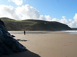
 Penbryn Beach | |
| Location | |
| Grid reference: | SN294520 |
| Location: | 52°8’24"N, 4°29’40"W |
| Data | |
| Post town: | Llandysul |
| Postcode: | SA44 |
| Dialling code: | 01239 |
| Local Government | |
| Council: | Ceredigion |
| Parliamentary constituency: |
Ceredigion |
Penbryn is a tiny village with a long, sandy beach on the coast of Cardiganshire, some ten miles up the coast from Cardigan. It sits between the villages of Tresaith and Llangrannog and consists mostly of farms and caravan sites.
Penbryn Beach is owned by the National Trust.
Near the village is the Corbalengi Stone, a monument of the Early Christian period inscribed: "CORBALENGI IACIT ORDOVS". "Ordovs" is generally agreed to be the local tribe, the Ordovices, but "Corbalengi" is not found elsewhere, and there are many theories as to the significance of the inscription.[1]
Miscellany
- Penbryn Beach was used for location filming for the James Bond film Die Another Day