Difference between revisions of "Moel Eilio"
| Line 8: | Line 8: | ||
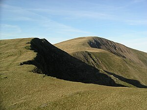
|picture caption=Moel Eilio from the south | |picture caption=Moel Eilio from the south | ||
|height=2,382 feet | |height=2,382 feet | ||
| + | |latitude=53.096884 | ||
| + | |longitude=-4.159533 | ||
|os grid ref=SH555577 | |os grid ref=SH555577 | ||
}} | }} | ||
| − | '''Moel Eilio''' is a mountain in [[Snowdonia]], in [[Caernarfonshire]]. It stands | + | '''Moel Eilio''' is a mountain in [[Snowdonia]], in [[Caernarfonshire]]. It stands north-west of [[Snowdon]], its summit approximately three miles from [[Snowdon]]'s. |
For those ascending Snowdon on the Llanberis Path, Moel Eilio is a familiar bulk, the great mountain rising up before Snowdon itself, its eastern face, facing the walker, scooped out into a craggy cliff almost to the summit, and beneath it rich green meadows gathered around [[Llyn Dwythwch]]. | For those ascending Snowdon on the Llanberis Path, Moel Eilio is a familiar bulk, the great mountain rising up before Snowdon itself, its eastern face, facing the walker, scooped out into a craggy cliff almost to the summit, and beneath it rich green meadows gathered around [[Llyn Dwythwch]]. | ||
| Line 21: | Line 23: | ||
A popular ascent starts from [[Llanberis]], and climbs by way of Bwlch y Groes and then the north ridge of the hill. | A popular ascent starts from [[Llanberis]], and climbs by way of Bwlch y Groes and then the north ridge of the hill. | ||
| − | Moel Eilio, Foel Gron, Foel Goch and [[Moel Cynghorion]] form a curved ridge tracking generally | + | Moel Eilio, Foel Gron, Foel Goch and [[Moel Cynghorion]] form a curved ridge tracking generally south-west towards Snowdon. This ridge can provide a less common route to ascend Snowdon,<ref>Marsh, Terry (1984). ''The Summits of Snowdonia'' (London: Robert Hale, 1984). ISBN 0-7090-1456-2.</ref><ref>Marsh, Terry. ''The Mountains of Wales'' (London: Hodder and Stoughton, 1985). ISBN 0-340-34827-5.</ref><ref>Nuttall, John & Anne (1999). The Mountains of England & Wales - Volume 1: Wales (2nd edition ed.). Milnthorpe: Cicerone. ISBN 1-85284-304-7.</ref> or on its own can be a rewarding walk, known as the Moel Eilio Horseshoe walk. |
==Foel Gron== | ==Foel Gron== | ||
| Line 27: | Line 29: | ||
'''Foel Gron''' is a subsidiary top of Moel Eilio, reaching 2,064 feet. Its name, ''Y Foel Gron'', means "The Round Hill". | '''Foel Gron''' is a subsidiary top of Moel Eilio, reaching 2,064 feet. Its name, ''Y Foel Gron'', means "The Round Hill". | ||
| − | The top stands at {{map|SH560568}}, on the Moel Eilio ridge | + | The top stands at {{map|SH560568}}, on the Moel Eilio ridge south-west of the main summit, halfway to Foel Goch. |
==Foel Goch== | ==Foel Goch== | ||
| − | '''Foel Goch''' (meaning "the Red Hill") is a subsidiary top of Moel Eilio, reaching 1,985 feet at its summit, {{map| SH570563}}. It is | + | '''Foel Goch''' (meaning "the Red Hill") is a subsidiary top of Moel Eilio, reaching 1,985 feet at its summit, {{map| SH570563}}. It is south-west of the main summit a little over a mile and a quarter away, and a mile west of the summit of [[Moel Cynghorion]]. It looks over [[Snowdon Ranger]] and [[Llyn Cwellyn]] in the valley below. |
==Outside links== | ==Outside links== | ||
Latest revision as of 17:09, 23 September 2018
| Moel Eilio | |||
| Caernarfonshire | |||
|---|---|---|---|
 Moel Eilio from the south | |||
| Range: | Snowdonia | ||
| Summit: | 2,382 feet SH555577 53°5’49"N, 4°9’34"W | ||
Moel Eilio is a mountain in Snowdonia, in Caernarfonshire. It stands north-west of Snowdon, its summit approximately three miles from Snowdon's.
For those ascending Snowdon on the Llanberis Path, Moel Eilio is a familiar bulk, the great mountain rising up before Snowdon itself, its eastern face, facing the walker, scooped out into a craggy cliff almost to the summit, and beneath it rich green meadows gathered around Llyn Dwythwch.
The hill has two subsidiary tops, Foel Gron and Foel Goch, on an equally craggy ridge heading south-eastwards from the summit, which ridge ultimately rises to Moel Cynghorion.
During the winter season, some significant accumulations of snowfall is known to take place on Moel Eilio, due to its relatively flat, grassy slopes.
Ascent, and the Horseshow Walk
A popular ascent starts from Llanberis, and climbs by way of Bwlch y Groes and then the north ridge of the hill.
Moel Eilio, Foel Gron, Foel Goch and Moel Cynghorion form a curved ridge tracking generally south-west towards Snowdon. This ridge can provide a less common route to ascend Snowdon,[1][2][3] or on its own can be a rewarding walk, known as the Moel Eilio Horseshoe walk.
Foel Gron
Foel Gron is a subsidiary top of Moel Eilio, reaching 2,064 feet. Its name, Y Foel Gron, means "The Round Hill".
The top stands at SH560568, on the Moel Eilio ridge south-west of the main summit, halfway to Foel Goch.
Foel Goch
Foel Goch (meaning "the Red Hill") is a subsidiary top of Moel Eilio, reaching 1,985 feet at its summit, SH570563. It is south-west of the main summit a little over a mile and a quarter away, and a mile west of the summit of Moel Cynghorion. It looks over Snowdon Ranger and Llyn Cwellyn in the valley below.
Outside links
- Pictures of Moel Eilio and the area on Geograph.co.uk
- Pictures of Foel Gron and the area on Geograph.co.uk
- Walking Routes to the Summit of Moel Eilio
References
- ↑ Marsh, Terry (1984). The Summits of Snowdonia (London: Robert Hale, 1984). ISBN 0-7090-1456-2.
- ↑ Marsh, Terry. The Mountains of Wales (London: Hodder and Stoughton, 1985). ISBN 0-340-34827-5.
- ↑ Nuttall, John & Anne (1999). The Mountains of England & Wales - Volume 1: Wales (2nd edition ed.). Milnthorpe: Cicerone. ISBN 1-85284-304-7.
