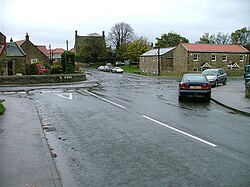
Melsonby
From Wikishire
| Melsonby | |
| Yorkshire North Riding | |
|---|---|
 Melsonby Village | |
| Location | |
| Grid reference: | NZ198084 |
| Location: | 54°28’15"N, 1°41’42"W |
| Data | |
| Population: | 735 (2011[1]) |
| Post town: | Richmond |
| Postcode: | DL10 |
| Dialling code: | 01325 |
| Local Government | |
| Council: | Richmondshire |
Melsonby is a village and civil parish in the North Riding of Yorkshire. It lies a mile and a half west of the A1(M) motorway and the same distance north of the A66.
Etymology
The second element in the name Melsonby is the Old Norse suffix -by,[2] meaning "farm, settlement". The first element may be the Old Irish personal name Maelsuithan,[2] which indicates Norse-Gaelic settlement in the area.[2]
References
| ("Wikimedia Commons" has material about Melsonby) |
- ↑ UK Census (2011). "Local Area Report – Melsonby Parish (1170217168)". Nomis. Office for National Statistics. https://www.nomisweb.co.uk/sources/census_2011_ks/report?compare=1170217168. Retrieved 4 June 2018
- ↑ 2.0 2.1 2.2 Stenton, Frank Merry (1970). Preparatory to Anglo-Saxon England: The Collected Papers of Frank Merry Stenton. Clarendon. p. 312. ISBN 0198223145. https://books.google.com/books?id=v1hMck3rF-MC. Retrieved 5 January 2019.