Difference between revisions of "Marriott's Way"
(Created page with "The Marriott’s Way on Thorpe Marriott village green {{county|Norfolk}} File:Marriott'sWayinSummer.jpg|right|thumb|200px|The...") |
(No difference)
|
Latest revision as of 13:47, 20 February 2024


The Marriott's Way is a footpath, cycle-path and bridleway in northern Norfolk, running for 24½ miles between Norwich and Aylsham by way of Themelthorpe. It forms part of the National Cycle Network Route 1 and the red route of Norwich's Pedalways cycle path network.[1]
- Trailheads
The route is open to walkers, cyclists and horse riders. It has a mixture of surfaces: tarmac, compacted gravel and earth. The name of the route originates from the chief engineer and manager of the Midland and Great Northern Joint Railway, William Marriott, who held the position for 41 years.[2]
Contents
Railway history
The path uses the trackbeds of two former railway lines: from Norwich to Themelthorpe and from Themelthorpe to Aylsham South. The Themelthorpe to Norwich line was built in 1882 by the Lynn and Fakenham Railway Company, which was taken over by the Midland and Great Northern in 1893 as part of a line that ran to Melton Constable; this line gave a through route to the Midlands. The Themelthorpe to Aylsham line was completed in 1893 by the Great Eastern Railway to provide a link to its other lines at Wroxham and County School, close to North Elmham. The lines were never profitable. Freight services were largely based on farm products and the line closed to passenger traffic in 1959.
In 1960, the two lines were joined by the so-called 'Themelthorpe Curve', believed to be the sharpest bend on the British Rail network. Its construction was to maintain the important movement of concrete products from Lenwade railway station; once production ceased in 1985, the line was closed.[2]
Route
At Norwich, the path begins to the north of the Barn Road and Barker Street Inner Ring Road roundabout; much of this area was part of the former Norwich City railway station. The path, which is also known as the Railway Path, follows approximately the course of the River Wensum which forms a boundary with the twelve-acre Train Wood.[3]

After crossing a footbridge, the industrial landscape gives way to the water-meadows of the Sweetbriar Road Meadows before crossing the Wensum over the A frame bridge at Hellesdon. Travelling in a northerly direction from the junction of Marlpit Lane and Hellesdon Road, through the site of the former Hellesdon railway station, the way soon crosses the tiny River Tud at Costessey. The tree-lined River Wensum can be seen to the east, as the path passes through the open country side of the Wensum Valley. The river is crossed by means of an A-frame bridge (there are only three in Norfolk), before arriving at Drayton.[4]
The original Drayton railway station is now an industrial estate; the path follows a gravel path before crossing a minor road and entering a deep cutting to cross the busy A1067 road, close to Taverham. To the west is Thorpe Marriott, a large housing estate built in the late 20th century.

The tranquil path passes through extensive mixed woodland of the Mileplain plantation to cross the Wensum below Attlebridge. To the east of the way, the circular Winch's Way[5] can be accessed which links to the Swannington and Alderford commons. After reaching a country lane, the privately-owned former Attlebridge railway station can be viewed; the way can be accessed close to a car park and picnic area. After passing through birch woods, the large industrial estate of Lenwade can be seen to the west of the way and water filled gravel pits to the east.

Crossing the Wensum for the last time, and close to the former Lenwade railway station which is now privately owned, and on to Whitwell railway station. The National Cycle Network route leaves Marriott's Way to follow a short cut along quiet lanes to Reepham. The way carries on to Themelthorpe and follows the curve to the important stop of Reepham railway station, where the preserved station and engineering shed can be found. Following an easterly course, the path passes close by to the village of Cawston on the B1145 road and then crosses the B1149 road. To the north, the way links to Blickling Hall via Weavers Way before reaching the end of the trail at Aylsham; directly opposite is Aylsham railway station and the Bure Valley Path, a walking and cycling route.[6]
Public works of art


Several concrete public works of art can be seen along the way, as a constant reminder of the line's connection with the concrete industry and of its last days as a freight line, carrying concrete products. Also on view are hand crafted benches and places to rest; many of these memorials are to cyclists and other way users.
The route is marked by steel benches, fabricated from flat-bottomed rail at intervals of 1 mile starting from the site of Norwich City station. Each bench is to a different design, often with the rail twisted or bent, but always with a flat length at sitting height.

Pictures
| ("Wikimedia Commons" has material about Marriott's Way) |
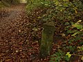
Concrete mile-post [1]
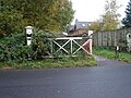
Level crossing at Lenwade


Coordinates: 52°39′45″N 1°13′47″E / 52.6626°N 1.2297°E
Outside links
| ("Wikimedia Commons" has material about Marriott's Way) |
See also
- Norfolk Trails
- Marriott’s Way (council)
- Sustrans
- Marriot's Way guide
- Horse riding
- Peter Boggis-Marriott's Way
- Winch's Way
- Norwich and Norfolk Naturalists' Society
References
- ↑ Norwich pedalways Retrieved 27 April 2015
- ↑ 2.0 2.1 Marriott's Way Retrieved 21 November 2008
- ↑ "Friends of Trainwood & Marriott's Way". http://trainwood.co.uk/. Retrieved 1 April 2018.
- ↑ 'A Frame bridge' Retrieved 21 November 2008
- ↑ Winch's Way Retrieved 27 April 2015
- ↑ Marriott's Way information Retrieved 31 January 2023