Lochgoilhead and Kilmorich
Lochgoilhead and Kilmorich is a joint parish of Argyllshire consisting of the ancient parishes of Lochgoilhead to the south and Kilmorich to the north. It contains the hamlets of Cairndow, Carrick Castle and Clachan and the Argyll Forest Park. It is bounded to the north by Glenorchy and Inishail, north-east by Killin (in Perthshire), east by Arrochar (in Dunbartonshire), south-east by the upper 10⅞ miles of salt-water Loch Long (½ mile broad), south-west by Dunoon and Kilmun, west by Strachur, and north-west by salt-water Loch Fyne and Inveraray. Its utmost length, from north to south, is 19 miles; its breadth varies between a mile and 11 miles; and its area is 110 square miles or 70,460 acres, of which 39,192 belong to the Lochgoilhead section, 191 are water, six tidal water, and 567 foreshore.
The northern division, extending from the vicinity of Benloy to the mountains which screen the northern side of Glencroe, includes Ben Bui (3,106 feet), Ben Ime (3,318), Ben Arthur (2,891), and Glenfyne.
The southern division, extending 10⅞ miles down Loch Long and 5 down Loch Fyne, is intersected by Loch Goil and includes Glencroe, Glenkinglas, Hell's Glen, Ben-anLochain (2,955 feet), Ben Bheula (2,557), Ben Donich (2,774), Ben Lochain (2,306), and Argyll's Bowling Green.
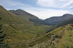
In all twenty-seven summits have a height of more than 2,000 feet above sea-level, and the surface everywhere is wildly mountainous and very rugged, abounding in vast bare rocky masses, and in stupendous cliffs and precipices. Caves, grottos, and natural vaults are very numerous; streams, rapid and romantic, but all of short length of course, run to the several sea lochs; and four small lakes, well stored with trout, lie high up among the hills.
Considerable pendicles of land on the coasts and in the glens are well cultivated and highly embellished; and a large aggregate of natural wood clothes much of the upland tracts, especially on and near the coasts, and charmingly hides or relieves the savageness of the mountain wastes. Eruptive and metamorphic rocks predominate; limestone has been worked in several quarries; at the head of Loch Fyne is a vein of lead ore, said to be very rich in silver; and jasper, several kinds of spar, and some other interesting minerals are found. The soil in the bottoms of some of the glens is rich and fertile; on patches of the coast lands is light, sharp, and sandy; in the high glens is generally wet and spongy, partly a deep moss; and on the pastoral uplands is mostly thin, dry, and firm to the tread of cattle.
This Argyllshire article is a stub: help to improve Wikishire by building it up.