Difference between revisions of "Loch Goil"
(Created page with "The mouth of Loch Goil, showing [[Loch Long, from Portincaple.]] {{county|Argyllshire}} '''Loch Goi...") |
|||
| (2 intermediate revisions by the same user not shown) | |||
| Line 1: | Line 1: | ||
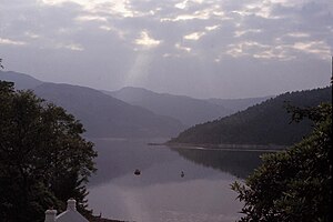
| − | [[File:Loch Goil and Loch Long from Portincaple.jpg|right|thumb|300px|The mouth of Loch Goil, showing | + | [[File:Loch Goil and Loch Long from Portincaple.jpg|right|thumb|300px|The mouth of Loch Goil, showing Loch Long, from Portincaple]] |
{{county|Argyllshire}} | {{county|Argyllshire}} | ||
'''Loch Goil''' is a small sea loch of [[Argyllshire]], branching of [[Loch Long]]. The village of [[Lochgoilhead]] stands at its head. | '''Loch Goil''' is a small sea loch of [[Argyllshire]], branching of [[Loch Long]]. The village of [[Lochgoilhead]] stands at its head. | ||
| Line 9: | Line 9: | ||
[[Carrick Castle]] stands on the west shore 4 miles south of [[Lochgoilhead]]. | [[Carrick Castle]] stands on the west shore 4 miles south of [[Lochgoilhead]]. | ||
| − | The loch | + | The landscape in which the loch lies is one of hills and soaring mountains, with gorgeous wild loch views, and so in spite of its isolation, the lochside has a range of accommodation and places for leisure activities and entertainment. |
| + | ==Sport== | ||
Several Sea Fishing shore records are attributed to the Loch: | Several Sea Fishing shore records are attributed to the Loch: | ||
{| class="wikitable" | {| class="wikitable" | ||
| Line 37: | Line 38: | ||
*[http://www.nls.uk/maps/detail.cfm?id=276 Map showing Loch Goyll (Loch Goil), circa 1600], National Library of Scotland | *[http://www.nls.uk/maps/detail.cfm?id=276 Map showing Loch Goyll (Loch Goil), circa 1600], National Library of Scotland | ||
| − | [[Category:Sea lochs of Argyllshire]] | + | [[Category:Sea lochs of Argyllshire|Goil]] |
| + | {{Slippy}} | ||
Latest revision as of 11:21, 10 February 2017
Loch Goil is a small sea loch of Argyllshire, branching of Loch Long. The village of Lochgoilhead stands at its head.
Loch Goil is an arm of Loch Long, branching north-northwest off the middle course of that well named loch, and described as a fjord-type sea loch. It is all within the Loch Lomond and the Trossachs National Park, at nestling beneath the Arrochar Alps,
Lochgoilhead at the head of the loch is an isolated village, whose sole road joining it to outside world is a 6-mile single-track road running north from the loch up to Rest and Be Thankful on the A83. The only other road from the village runs down the loch to farms and Carrick Castle, and a dead-end.
Carrick Castle stands on the west shore 4 miles south of Lochgoilhead.
The landscape in which the loch lies is one of hills and soaring mountains, with gorgeous wild loch views, and so in spite of its isolation, the lochside has a range of accommodation and places for leisure activities and entertainment.
Sport
Several Sea Fishing shore records are attributed to the Loch:
| Species | Weight | Angler / Year |
|---|---|---|
| Gurnard, Streaked | 01-06-08 | H. L. Smith, 1971 |
| Haddock | 06-12-00 | G. Stevenson, 1976 |
| Pipefish, Greater | 00-01-13 | J.C. Ogilvie, 1992 |
| Wrasse, Goldsinny | 00-01-13 | T. Lambert, 1977 |
The landscape at Loch Goil shows its remoteness and Highland grandeur with the Arrochar Alps surrounded with conifers, that shows off some of the might of the Highlands just an hour from Glasgow.
The loch is used for exercises by Vanguard class Trident submarines from HMNB Clyde at Faslane.
|
|
Outside links
- Map showing Loch Goyll (Loch Goil), circa 1600, National Library of Scotland
