Difference between revisions of "Llangua"
From Wikishire
(Created page with "{{Infobox town |name=Llangua |county=Monmouthshire |picture=St. James' Church, Llangua - geograph.org.uk - 1286109.jpg |picture caption=St James' church |os grid ref=SO392260 ...") |
|||
| (One intermediate revision by the same user not shown) | |||
| Line 10: | Line 10: | ||
|postcode=NP7 | |postcode=NP7 | ||
|dialling code=01873 | |dialling code=01873 | ||
| − | |population= | + | |population=77 |
|census year= | |census year= | ||
|LG district=Monmouthshire | |LG district=Monmouthshire | ||
| Line 17: | Line 17: | ||
'''Llangua''' is a village and ancient parish in [[Monmouthshire]], nine miles north-east of [[Abergavenny]] on the A465 road. | '''Llangua''' is a village and ancient parish in [[Monmouthshire]], nine miles north-east of [[Abergavenny]] on the A465 road. | ||
| − | Llangua sits close to the [[Herefordshire]] border on the Monmouthshire bank of the [[River Monnow]] | + | Llangua sits close to the [[Herefordshire]] border on the Monmouthshire bank of the [[River Monnow]], although the parish church is part of the [[Diocese of Hereford]]. [[Grosmont, Monmouthshire|Grosmont]] is one mile to the south-east. |
Nearby [[Pontrilas]] just inside [[Herefordshire]] on the railway line from [[Newport, Monmouthshire|Newport]] to [[Hereford]] has been identified a potential location of a re-opened station. | Nearby [[Pontrilas]] just inside [[Herefordshire]] on the railway line from [[Newport, Monmouthshire|Newport]] to [[Hereford]] has been identified a potential location of a re-opened station. | ||
{{commonscat}} | {{commonscat}} | ||
| − | == | + | ==Outside links== |
*[http://www.genuki.org.uk/big/wal/MON/Llangua/index.html Genuki info on Llangua] | *[http://www.genuki.org.uk/big/wal/MON/Llangua/index.html Genuki info on Llangua] | ||
*[http://www.genebooks.com/bradney/skenfrith/llangua.htm Bradney on Llangua] | *[http://www.genebooks.com/bradney/skenfrith/llangua.htm Bradney on Llangua] | ||
Latest revision as of 14:39, 7 January 2016
| Llangua | |
| Monmouthshire | |
|---|---|
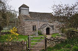
 St James' church | |
| Location | |
| Grid reference: | SO392260 |
| Location: | 51°55’45"N, 2°53’8"W |
| Data | |
| Population: | 77 |
| Post town: | Abergavenny |
| Postcode: | NP7 |
| Dialling code: | 01873 |
| Local Government | |
| Council: | Monmouthshire |
| Parliamentary constituency: |
Monmouth |
Llangua is a village and ancient parish in Monmouthshire, nine miles north-east of Abergavenny on the A465 road.
Llangua sits close to the Herefordshire border on the Monmouthshire bank of the River Monnow, although the parish church is part of the Diocese of Hereford. Grosmont is one mile to the south-east.
Nearby Pontrilas just inside Herefordshire on the railway line from Newport to Hereford has been identified a potential location of a re-opened station.
| ("Wikimedia Commons" has material about Llangua) |
Outside links
- Genuki info on Llangua
- Bradney on Llangua
- Kelly's 1901 Directory of Monmouthshire on Llangua
- www.geograph.co.uk : photos of Llangua and surrounding area