Difference between revisions of "Llandough juxta Cowbridge"
From Wikishire
(Created page with "{{Infobox town |county=Glamorgan ||latitude=51.45 |longitude=-3.45 |picture=The Cottage, Llandough. - geograph.org.uk - 159822.jpg |post town=Cowbridge |postcode=CF71 |diallin...") |
|||
| Line 1: | Line 1: | ||
| + | {{Hatnote|For Llandough near Cardiff, see [[Llandough juxta Cardiff]]}} | ||
{{Infobox town | {{Infobox town | ||
|county=Glamorgan | |county=Glamorgan | ||
Revision as of 09:38, 6 April 2016
For Llandough near Cardiff, see Llandough juxta Cardiff
| Llandough juxta Cowbridge | |
| Glamorgan | |
|---|---|

| |
| Location | |
| Location: | 51°27’0"N, 3°27’0"W |
| Data | |
| Post town: | Cowbridge |
| Postcode: | CF71 |
| Dialling code: | 01446 |
| Local Government | |
| Council: | Vale of Glamorgan |
| Parliamentary constituency: |
Vale of Glamorgan |
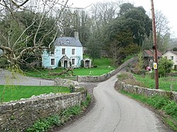
Llandough otherwise Llandough juxta Cowbridge is a village and ancient parish located south of Cowbridge in Glamorgan. Its full name is used to distinguish this parish from the other Llandough in the county.
Notable landmarks
The following are listed buildings:
- Church of St Dochdwy (II)
- Llandough Castle (II*)
- Llandough Castle Flats (II) (SAM)
- Llandough Gatehouse and attached boundary walls (II*)
- North-east, South-east, and South-west walls, gatepiers and railings enclosing Llandough Castle and Gatehouse (II) (SAM)
- Village Hall (II)
- The Rectory (II)