Lisburn
| Lisburn | |
| County Antrim | |
|---|---|
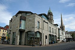
 Irish Linen Museum and Christ Church Cathedral | |
| Location | |
| Location: | 54°30’43"N, 6°1’52"W |
| Data | |
| Population: | 71,465 (2001) |
| Post town: | Lisburn |
| Postcode: | BT27, BT28 |
| Dialling code: | 028 |
| Local Government | |
| Council: | Lisburn City Council |
| Parliamentary constituency: |
Lagan Valley |
Lisburn is a city of County Antrim, standing south-west of Belfast on the River Lagan, which forms the boundary between County Antrim and County Down. Lisburn is Northern Ireland's third-largest city, and received its city status in 2002 as part of Queen Elizabeth II's Golden Jubilee celebrations.
Name
The city was originally known as Lisnagarvey, said to come from the Gaelic Lios na gCearrbhach, or "fort of the gamblers". Cathedral records suggest that the name Lisburn came into common use around 1662.
The headquarters of the British Army in Northern Ireland at Thiepval Barracks and the headquarters of the Northern Ireland Fire Brigade are located in the city.
History
Lisburn's original site was located on what is now known as Hill Street, on a hill above the River Lagan. Its origin was in 1611 when King James I granted Sir Fulke Conway the lands of Killultagh in south western Antrim. Lisburn's original streets were laid out during the 1620s; Market Square, Bridge Street, Castle Street and Bow Street. Sir Fulke built a manor house on what is now Castle Gardens and brought many settlers from England and Wales. In 1623 he built a church on the site of the current cathedral. The Manor House was destroyed in the accidental fire of 1707 and was never rebuilt.
Negotiations preceding the American War of Independence between Ben Franklin and Lord Hillsborough took place at Hillsborough near the town.
Lisburn is also known as the birthplace of Ireland's linen industry, which was established in 1698 by Louis Crommelin and other Huguenots. An exhibition about the Irish linen industry is now housed in the Irish Linen Centre, which can be found in the town’s old Market House in Market Square.[1]
Between 1954 and 1992 Lisburn contained the operational headquarters of No 31 Belfast Group Royal Observer Corps[2] who operated from a protected nuclear bunker on Knox Road within Thiepval Barracks. Converted from a 1940s Anti-aircraft Operations Room (AAOR) the bunker would support over one hundred ROC volunteers and a ten man United Kingdom Warning and Monitoring Organisation warning team responsible for the famous "four-minute warning" in the event of a nuclear strike on the United Kingdom. The ROC would also have detected radioactive fallout from the nuclear bursts and warned the public of approaching fallout. Thankfully it was never called upon so to act. The two organisations were stood down in 1992 at the end of the Cold War.
Local government
Lisburn gives its name to a local government district governed by Lisburn City Council[3], which also includes Hillsborough, Moira, Dromara, Glenavy, Dunmurry and Drumbo.
Churches
Lisburn is notable for its large number of churches; in the wider Lisburn City area, 134 churches are listed.[4]
The Church of Ireland's Diocese of Connor has one of its two cathedral's in Lisburn: Christ Church Cathedral.

