Kiln Green
From Wikishire
Revision as of 22:49, 15 December 2014 by RB (Talk | contribs) (Created page with "{{Infobox town |name=Kiln Green |county=Berkshire |picture=Kiln Green - geograph.org.uk - 24587.jpg |picture caption=A lane in Kiln Green |os grid ref=SU815785 |latitude=51.49...")
| Kiln Green | |
| Berkshire | |
|---|---|
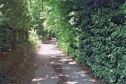
 A lane in Kiln Green | |
| Location | |
| Grid reference: | SU815785 |
| Location: | 51°29’58"N, 0°49’38"W |
| Data | |
| Postcode: | RG10 |
| Local Government | |
| Council: | Wokingham |
Kiln Green is a small village in eastern Berkshire, within the civil parish of Wargrave.
The village stands by the A4 Bath Road between Knowl Hill to the east and Hare Hatch to the west. The village includes Linden Hill to the north and Scarletts to the south.
The Castle Royle Golf Country Club is here, which includes a gym, a swimming pool and a golf course.
Outside links
| ("Wikimedia Commons" has material about Kiln Green) |