Difference between revisions of "Hycemoor"
From Wikishire
(Created page with "{{Infobox town |name=Hycemoor |county=Cumberland |picture=Rural Red Kiosk. - geograph.org.uk - 285467.jpg |picture caption=A red telephone box in Hycemoor |os grid ref=SD09389...") |
m |
||
| Line 15: | Line 15: | ||
|constituency=Copeland | |constituency=Copeland | ||
}} | }} | ||
| − | '''Hycemoor''' is a hamlet in south-western [[Cumberland]] | + | '''Hycemoor''' is a hamlet in south-western [[Cumberland]]. |
The village is on a minor road about a mile away from the village of [[Bootle, Cumberland|Bootle]] and the A595 road. The nearest railway station is in the neighbouring hamlet of Bootle Station. | The village is on a minor road about a mile away from the village of [[Bootle, Cumberland|Bootle]] and the A595 road. The nearest railway station is in the neighbouring hamlet of Bootle Station. | ||
Latest revision as of 09:54, 28 September 2019
| Hycemoor | |
| Cumberland | |
|---|---|
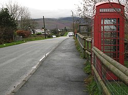
 A red telephone box in Hycemoor | |
| Location | |
| Grid reference: | SD093892 |
| Location: | 54°17’28"N, 3°23’35"W |
| Data | |
| Post town: | Millom |
| Postcode: | LA19 |
| Dialling code: | 01229 |
| Local Government | |
| Council: | Cumberland |
| Parliamentary constituency: |
Copeland |
Hycemoor is a hamlet in south-western Cumberland.
The village is on a minor road about a mile away from the village of Bootle and the A595 road. The nearest railway station is in the neighbouring hamlet of Bootle Station.
Outside links
| ("Wikimedia Commons" has material about Hycemoor) |