Difference between revisions of "Hangman's Hill"
From Wikishire
(Created page with '{{Infobox hill |name=Hangman's Hill |county 1=Herefordshire |county 2=Worcestershire |range=Malvern Hills |picture=Hangman's Hill - geograph.org.uk - 618865.jpg |picture caption=…') |
|||
| Line 7: | Line 7: | ||
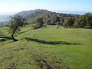
|picture caption=On Hangman's Hill looking south | |picture caption=On Hangman's Hill looking south | ||
|os grid ref=SO761392 | |os grid ref=SO761392 | ||
| + | |latitude=52.0502 | ||
| + | |longitude=-2.3485 | ||
|height=906 feet | |height=906 feet | ||
}} | }} | ||
Latest revision as of 18:15, 11 April 2024
| Hangman's Hill | |||
| Herefordshire, Worcestershire | |||
|---|---|---|---|
 On Hangman's Hill looking south | |||
| Range: | Malvern Hills | ||
| Summit: | 906 feet SO761392 52°3’1"N, 2°20’55"W | ||
Hangman's Hill is amongst the Malvern Hills, on the long ridge of the hills with its top on the border of Herefordshire and Worcestershire. It lies to the south of Broad Down and north of Swinyard Hill. The western, Herefordshire, slope descends into the News Wood.
The Shire Ditch runs across the top, on its way north to the Worcestershire Beacon.