Graffham
| Graffham | |
| Sussex | |
|---|---|
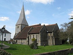
 Parish church of St Giles, Graffham | |
| Location | |
| Grid reference: | SU927175 |
| Location: | 50°56’60"N, 0°40’51"W |
| Data | |
| Population: | 516 (2011) |
| Post town: | Petworth |
| Postcode: | GU28 |
| Dialling code: | 01798 |
| Local Government | |
| Council: | Chichester |
| Parliamentary constituency: |
Chichester |
| Website: | graffhamonline.co.uk |
Graffham is a village in Sussex, on the northern escarpment of the South Downs. The civil parish is made up of the village of Graffham, part of the hamlet of Selham, and South Ambersham
History
Graffham was listed in the Domesday Book (1086) as having 13 households: seven villagers and six smallholders; with land for ploughing, woodland for pigs and a church, the parish's value to the lord of the manor was £8.[1]
The 1861 census recorded that the parish covered 1,658 acres and had a population of 410.[2] Selham was still a separate parish covering 1,042 acre with a population of 123.[3]
About the village
The village of Graffham contains two pubs The Forester's Arms and The White Horse, a recreation ground, a village shop, the parish church of St Giles, which was largely rebuilt between 1874 and 1887, and a primary school. Seaford College, an independent school, is close by.
Outside links
| ("Wikimedia Commons" has material about Graffham) |
References
- ↑ Graffham in the Domesday Book
- ↑ Information on Graffham from GENUKI
- ↑ Information on Graffham from GENUKI
