Difference between revisions of "Glen Loy Aqueduct"
From Wikishire
(Created page with "{{Infobox bridge |name=Glen Loy Aqueduct |county=Inverness |type=Aquaduct |picture=Glen Loy Aqueduct, Caledonain Canal (geograph 3285838).jpg |latitude=56.8903 |longitude=-5.0...") |
|||
| Line 22: | Line 22: | ||
{{reflist}} | {{reflist}} | ||
{{commons}} | {{commons}} | ||
| + | [[Category:Aqueducts in Inverness-shire]] | ||
{{stub}} | {{stub}} | ||
Revision as of 12:49, 8 December 2017
| Glen Loy Aqueduct | |
| Inverness-shire | |
|---|---|

| |
| Location | |
| Type: | Aquaduct |
| Location | |
| Location: | 56°53’25"N, 5°2’23"W |
| Structure | |
| Type: | Aquaduct |
| History | |
| Built 1806 | |
| Information | |
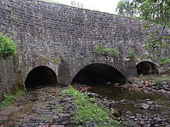
The Glen Loy Aqueduct (or Glenloy Aqueduct) carries the Caledonian Canal over the River Loy in Inverness-shire, near Muirshearlich, between Banavie and Gairlochy.
History
The aqueduct was built between March and October 1806.[1]
Design
It has three arches, of spans 10 ft, 25 ft and 10 ft.[1] The river runs through the middle arch, and roadways for pedestrian or animal use through the side arches paved with large cobbles.[2][3] The road tunnels are approximately 260 ft long under the canal.[3]
It is one of six aqueducts between Neptune's Staircase and Loch Lochy.[1]
References
| ("Wikimedia Commons" has material about Glen Loy Aqueduct) |
This Inverness-shire article is a stub: help to improve Wikishire by building it up.