Difference between revisions of "Garvetagh"
From Wikishire
(Created page with '{{Infobox town |name=Garvetagh |county=Tyrone |picture= |picture caption= |os grid ref=H2781 |LG district=Strabane }} '''Garvetagh''' is a village in Tyrone. {{stub}}') |
|||
| Line 1: | Line 1: | ||
{{Infobox town | {{Infobox town | ||
|name=Garvetagh | |name=Garvetagh | ||
| − | |county=Tyrone | + | |county=Tyrone |
| − | |picture= | + | |picture=St Andrew's Church of Ireland - geograph.org.uk - 390019.jpg |
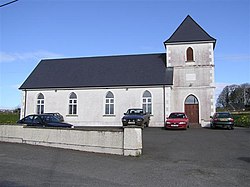
| − | |picture caption= | + | |picture caption=St Andrew's Church, Garvetagh |
| − | |os grid ref= | + | |os grid ref=H273818 |
| − | |LG district=Strabane | + | |latitude=54.684 |
| + | |longitude=-7.578 | ||
| + | |population= | ||
| + | |census year= | ||
| + | |post town= | ||
| + | |postcode= | ||
| + | |dialling code=028 | ||
| + | |townland=yes | ||
| + | |LG district=Derry and Strabane | ||
| + | |constituency= | ||
}} | }} | ||
| − | '''Garvetagh''' is a village in [[Tyrone]]. | + | '''Garvetagh''' is a small village and townland in [[Tyrone]], near [[Castlederg]]. The 2001 Census recorded a population of just 69 people. |
| + | |||
| + | [[File:First Castlederg Presbyterian Church - geograph.org.uk - 371793.jpg|thumb|Presbyterian church]] | ||
| + | [[File:Garvetagh Primary School - Garvetagh Church Hall - geograph.org.uk - 3806417.jpg|thumb|Primary school and church hall]] | ||
| + | {{commons}} | ||
| + | ==References== | ||
| + | {{reflist}} | ||
{{stub}} | {{stub}} | ||
Latest revision as of 21:53, 2 December 2022
| Garvetagh | |
| Tyrone | |
|---|---|
 St Andrew's Church, Garvetagh | |
| Location | |
| Grid reference: | H273818 |
| Location: | 54°41’2"N, 7°34’41"W |
| Data | |
| Dialling code: | 028 |
| Local Government | |
| Council: | Derry and Strabane |
Garvetagh is a small village and townland in Tyrone, near Castlederg. The 2001 Census recorded a population of just 69 people.
| ("Wikimedia Commons" has material about Garvetagh) |

