Difference between revisions of "Gallowstree Common"
From Wikishire
(Created page with "{{Infobox town |name=Gallowstree Common |picture=Gallowstree Common pub.jpg |picture caption=The Reformation Public House |county=Oxfordshire |os grid ref=SU690801 |latitude=5...") |
(No difference)
|
Latest revision as of 15:00, 19 February 2024
| Gallowstree Common | |
| Oxfordshire | |
|---|---|
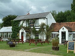
 The Reformation Public House | |
| Location | |
| Grid reference: | SU690801 |
| Location: | 51°30’58"N, 1°0’22"W |
| Data | |
| Post town: | Reading |
| Postcode: | RG4 |
| Dialling code: | 0118 |
| Local Government | |
| Council: | South Oxfordshire |
| Parliamentary constituency: |
Henley |
| Website: | Kidmore End Parish Council |
Gallowstree Common is a hamlet in Oxfordshire, in the south-east of the county, in the Chilterns Hills aa mile west of Sonning Common, and about four and a half miles north of the River Thames and Reading, across the river in Berkshire.
The village once had a public house, the Reformation, but the brewery sold the pub garden for housing and the pub to be turned into a vet's surgery. The village has two woods: New Copse to the north and Withy Copse to the west. A village barely bigger, Kidmore End, sits just to the south.
Outside links
| ("Wikimedia Commons" has material about Gallowstree Common) |