Difference between revisions of "Fiddler's Island"
m |
m |
||
| Line 1: | Line 1: | ||
{{county|Oxford}} | {{county|Oxford}} | ||
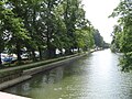
[[File:The Thames Path on Fiddler's Island - geograph.org.uk - 1758537.jpg|thumb|The Thames Path on Fiddler's Island<ref>{{cite web| url=http://www.thames-path.org.uk/thames_oxford_northmoor.html | title=Oxford to Northmoor | work=[http://www.thames-path.org.uk The Thames Path National Trail] | location=UK | accessdate=18 September 2012 }}</ref>]] | [[File:The Thames Path on Fiddler's Island - geograph.org.uk - 1758537.jpg|thumb|The Thames Path on Fiddler's Island<ref>{{cite web| url=http://www.thames-path.org.uk/thames_oxford_northmoor.html | title=Oxford to Northmoor | work=[http://www.thames-path.org.uk The Thames Path National Trail] | location=UK | accessdate=18 September 2012 }}</ref>]] | ||
| − | '''Fiddler's Island''' is an island in the [[River Thames]] at [[Oxford]]. It is situated south of Port Meadow on the reach above [[Osney Lock]]. | + | '''Fiddler's Island''' is an island in the [[River Thames]] at [[Oxford]]. It is situated south of [[Port Meadow]] on the reach above [[Osney Lock]]. |
The north part of the island sits between the River Thames and the top end of [[Castle Mill Stream]], a Thames backwater. '''Fiddler's Island Stream''' flows to the east of the southern part of the island. To the south of the island, there is a short stretch of water known as the [[Sheepwash Channel]] linking back to the Castle Mill Stream and the [[Oxford Canal]].<ref name="canalplan">{{cite web| url=http://canalplan.org.uk/waterway/edm8 | title=River Thames (Sheepwash Channel) | publisher=[http://canalplan.org.uk/ CanalPlanAC] | location=UK | accessdate=15 September 2012 }}</ref> The [[Thames Path]] runs the length of the complete island. At the northern end, the island has a row of trees along it. On the Castle Mill Stream side there is extensive mooring. The rainbow-shaped [[Medley Footbridge]] crosses the main stream of the Thames to the west at the northern end and a flat iron Bailey bridge crosses Castle Mill Stream further south, linking it to Port Meadow to the east. A small footbridge takes the Thames Path along the bank towards [[Osney Bridge]]. The northern part of Fiddler's Island is very thin.<ref>{{cite web| url=http://wikimapia.org/15699329/Fiddler-s-Island | title=Fiddler's Island (Oxford) (north) | publisher=Wikimapia | accessdate=18 September 2012 }}</ref> The southern part, connected by a footbridge, is wider.<ref>{{cite web| url=http://wikimapia.org/10611755/Fiddler-s-Island | title=Fiddler's Island (Oxford) (south) | publisher=Wikimapia | accessdate=18 September 2012 }}</ref> To the east is Cripley Meadow, largely consisting of allotments. | The north part of the island sits between the River Thames and the top end of [[Castle Mill Stream]], a Thames backwater. '''Fiddler's Island Stream''' flows to the east of the southern part of the island. To the south of the island, there is a short stretch of water known as the [[Sheepwash Channel]] linking back to the Castle Mill Stream and the [[Oxford Canal]].<ref name="canalplan">{{cite web| url=http://canalplan.org.uk/waterway/edm8 | title=River Thames (Sheepwash Channel) | publisher=[http://canalplan.org.uk/ CanalPlanAC] | location=UK | accessdate=15 September 2012 }}</ref> The [[Thames Path]] runs the length of the complete island. At the northern end, the island has a row of trees along it. On the Castle Mill Stream side there is extensive mooring. The rainbow-shaped [[Medley Footbridge]] crosses the main stream of the Thames to the west at the northern end and a flat iron Bailey bridge crosses Castle Mill Stream further south, linking it to Port Meadow to the east. A small footbridge takes the Thames Path along the bank towards [[Osney Bridge]]. The northern part of Fiddler's Island is very thin.<ref>{{cite web| url=http://wikimapia.org/15699329/Fiddler-s-Island | title=Fiddler's Island (Oxford) (north) | publisher=Wikimapia | accessdate=18 September 2012 }}</ref> The southern part, connected by a footbridge, is wider.<ref>{{cite web| url=http://wikimapia.org/10611755/Fiddler-s-Island | title=Fiddler's Island (Oxford) (south) | publisher=Wikimapia | accessdate=18 September 2012 }}</ref> To the east is Cripley Meadow, largely consisting of allotments. | ||
Latest revision as of 16:45, 22 August 2022

Fiddler's Island is an island in the River Thames at Oxford. It is situated south of Port Meadow on the reach above Osney Lock.
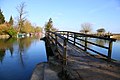
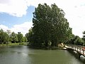
The north part of the island sits between the River Thames and the top end of Castle Mill Stream, a Thames backwater. Fiddler's Island Stream flows to the east of the southern part of the island. To the south of the island, there is a short stretch of water known as the Sheepwash Channel linking back to the Castle Mill Stream and the Oxford Canal.[2] The Thames Path runs the length of the complete island. At the northern end, the island has a row of trees along it. On the Castle Mill Stream side there is extensive mooring. The rainbow-shaped Medley Footbridge crosses the main stream of the Thames to the west at the northern end and a flat iron Bailey bridge crosses Castle Mill Stream further south, linking it to Port Meadow to the east. A small footbridge takes the Thames Path along the bank towards Osney Bridge. The northern part of Fiddler's Island is very thin.[3] The southern part, connected by a footbridge, is wider.[4] To the east is Cripley Meadow, largely consisting of allotments.
Fiddler's Island was authorised for public bathing by the Oxford Corporation in 1852, probably the first place in Oxford to be approved by the council.[5]
Gallery
The northern part of Fiddler's Island looking downstream from Medley Footbridge
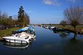
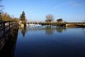
Moorings on Fiddler's Island in the Castle Mill Stream
The Thames Path footbridge on Fiddler's Island, looking north
Looking south across the Thames Path footbridge
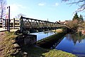
Bailey bridge from Port Meadow to Fiddler's Island
View looking north of the two footbridges at the northern end of Fiddler's Island, with Port Meadow on the right


See also
References
- Location map: 51°45’49"N, 1°16’48"W
- ↑ "Oxford to Northmoor". The Thames Path National Trail. UK. http://www.thames-path.org.uk/thames_oxford_northmoor.html. Retrieved 18 September 2012.
- ↑ "River Thames (Sheepwash Channel)". UK: CanalPlanAC. http://canalplan.org.uk/waterway/edm8. Retrieved 15 September 2012.
- ↑ "Fiddler's Island (Oxford) (north)". Wikimapia. http://wikimapia.org/15699329/Fiddler-s-Island. Retrieved 18 September 2012.
- ↑ "Fiddler's Island (Oxford) (south)". Wikimapia. http://wikimapia.org/10611755/Fiddler-s-Island. Retrieved 18 September 2012.
- ↑ Crossley, Alan (1939). Salzman, Louis Francis; Page, William. eds. The Victoria history of the county of Oxford. Victoria history of the counties of England. Volume 4. Oxford University Press for University of London, Institute of Historical Research. p. 428. https://books.google.com/books?ei=ZtpZUPqpBeO90QX4-oD4Aw&id=_zZWAAAAYAAJ&dq=%22Fiddler%27s+Island%22.