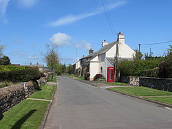
Ellonby
From Wikishire
Revision as of 18:49, 10 July 2017 by RB (Talk | contribs) (Created page with "{{Infobox town |name=Ellonby |county=Cumberland |picture=Cut Lawns & K6 in Ellonby (geograph 4497155).jpg |picture caption=Ellonby |os grid ref=NY424352 |latitude=54.709 |long...")
| Ellonby | |
| Cumberland | |
|---|---|
 Ellonby | |
| Location | |
| Grid reference: | NY424352 |
| Location: | 54°42’32"N, 2°53’35"W |
| Data | |
| Post town: | Penrith |
| Postcode: | CA11 |
| Dialling code: | 017684 |
| Local Government | |
| Council: | Westmorland & Furness |
| Parliamentary constituency: |
Penrith and The Border |
Ellonby is a hamlet in the parish of Skelton in Cumberland, less than a mile west of Skelton itself, in the hill open country, six and a half miles north-west of Penrith.
To the north of the hamlet, at Hardrigg Hall, a ruined 14th century pele tower adjoins a 19th-century farmhouse.[1]
| ("Wikimedia Commons" has material about Ellonby) |
References
- ↑ Hardrigg Hall Farmhouse with tower barn - British Listed Buildings