Difference between revisions of "East Holme"
(Created page with "{{Infobox town |name=East Holme |county=Dorset |picture=East Holme, terraced cottages - geograph.org.uk - 1415323.jpg |picture caption=East Holme |os grid ref=SY895860 |latitu...") |
(No difference)
|
Latest revision as of 22:28, 26 May 2020
| East Holme | |
| Dorset | |
|---|---|
 East Holme | |
| Location | |
| Grid reference: | SY895860 |
| Location: | 50°40’21"N, 2°8’53"W |
| Data | |
| Population: | 50 |
| Post town: | Wareham |
| Postcode: | BH20 |
| Local Government | |
| Council: | Dorset |
| Parliamentary constituency: |
South Dorset |
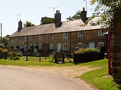
East Holme is a small village situated about halfway between Wool and Wareham in Dorset. The village is sprawled around a large house called Holme Priory. In 2013 the estimated population of the civil parish was 50.
The South West Main Line from London Waterloo to Weymouth runs through the village and, although the train does not stop, the village contains one of only a few of the remaining manned gate crossings. These have become particularly rare in the area.
Parish church
East Holme's parish church is St John the Evangelist, which stands apart from the rest of the village. The footpath across the park to the church is signposted and crosses in front of the priory, a fine late 18th century house, built on the site of a former, small Cluniac priory.
Following the dissolution the Priory church survived as the parish church until 1715. A new parish church was built in 1865 to the designs of John Hicks, and is one of his more elaborate churches. Now it has a faintly seedy air, which somehow suits this fine example of high Victorian taste. Built from local materials - dark brown heathstone quarried close by, With a Purbeck limestone roof, and Purbeck Marble shafts inside,
Outside links
| ("Wikimedia Commons" has material about East Holme) |