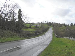
Drumcreen
From Wikishire
Revision as of 21:34, 15 December 2020 by RB (Talk | contribs) (Created page with "{{Infobox town |name=Drumcreen |county=Fermanagh |picture=Road at Drumcreen - geograph.org.uk - 349703.jpg |picture caption=Drumcreen |os grid ref=H275529 |latitude=54.4244444...")
| Drumcreen | |
| Fermanagh | |
|---|---|
 Drumcreen | |
| Location | |
| Grid reference: | H275529 |
| Location: | 54°25’28"N, 7°34’38"W |
| Data | |
| Local Government | |
| Council: | Fermanagh and Omagh |
| Parliamentary constituency: |
Fermanagh and South Tyrone |
Drumcreen is a village and townland in Fermanagh. The townland encompasses 123 acres and is within the Barony of Tirkennedy.[1]
References
- ↑ "Drumcreen Townland, Co. Fermanagh". townlands.ie. https://www.townlands.ie/fermanagh/tirkennedy/magheracross/drumcreen/. Retrieved 9 March 2020.
This Fermanagh article is a stub: help to improve Wikishire by building it up.