Dowland
From Wikishire
Revision as of 23:00, 21 August 2018 by RB (Talk | contribs) (Created page with "{{Infobox town |name=Dowland |county=Devon |picture=St Peter's Church, Dowland - geograph.org.uk - 71789.jpg |picture caption=St Peter's Church |os grid ref=SS568103 |latitud...")
| Dowland | |
| Devon | |
|---|---|
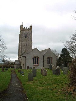
 St Peter's Church | |
| Location | |
| Grid reference: | SS568103 |
| Location: | 50°52’29"N, 4°2’8"W |
| Data | |
| Post town: | Winkleigh |
| Postcode: | EX19 |
| Dialling code: | 01805 |
| Local Government | |
| Council: | Torridge |
Dowland is a small village in northern Devon, west of the valley of the River Torridge. The nearest village is Dolton to the north.
The village has a church, St Peter's, amidst the buildings of Bridlescombe Farm.
| ("Wikimedia Commons" has material about Dowland) |