Difference between revisions of "Darlingscott"
(Additions) |
|||
| Line 15: | Line 15: | ||
'''Darlingscott''' is a small settlement in a detached part of [[Worcestershire]], locally situate in [[Warwickshire]]. It is two miles north-west of [[Shipston-on-Stour]] in the same detached part, and two miles south-east of [[Ilmington]] in Warwickshire proper. The [[Fosse Way]], a major [[Roman road]] (now marked by the modern A429 trunk road) passes close by to the south-east. Population details can be found under [[Tredington, Warwickshire|Tredington]]. | '''Darlingscott''' is a small settlement in a detached part of [[Worcestershire]], locally situate in [[Warwickshire]]. It is two miles north-west of [[Shipston-on-Stour]] in the same detached part, and two miles south-east of [[Ilmington]] in Warwickshire proper. The [[Fosse Way]], a major [[Roman road]] (now marked by the modern A429 trunk road) passes close by to the south-east. Population details can be found under [[Tredington, Warwickshire|Tredington]]. | ||
| − | The hamlet is isolated in the gentle hills that fill the south of Warwickshire, on the lane between Shipton-on-Stour | + | The hamlet is isolated in the gentle hills that fill the south of Warwickshire, on the lane between Shipton-on-Stour and Ilmington, and may be found seven and a half miles south of [[Stratford-upon-Avon]]. |
==Parish church== | ==Parish church== | ||
Revision as of 20:41, 12 February 2018
| Darlingscott | |
| Worcestershire, Warwickshire | |
|---|---|
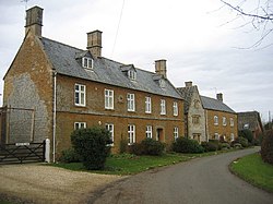
 Darlingscott House and Lower Farmhouse | |
| Location | |
| Grid reference: | SP2343 |
| Location: | 52°4’38"N, 1°39’42"W |
| Data | |
| Post town: | Shipston-on-Stour |
| Postcode: | CV35 |
| Dialling code: | 01608 |
| Local Government | |
| Council: | Stratford-on-Avon |
| Parliamentary constituency: |
Stratford-on-Avon |
Darlingscott is a small settlement in a detached part of Worcestershire, locally situate in Warwickshire. It is two miles north-west of Shipston-on-Stour in the same detached part, and two miles south-east of Ilmington in Warwickshire proper. The Fosse Way, a major Roman road (now marked by the modern A429 trunk road) passes close by to the south-east. Population details can be found under Tredington.
The hamlet is isolated in the gentle hills that fill the south of Warwickshire, on the lane between Shipton-on-Stour and Ilmington, and may be found seven and a half miles south of Stratford-upon-Avon.
Parish church
The parish church, St Mary The Virgin, stands just outside the hamlet, in its own acre at the western edge of the village. A church has stood here in some form since the early 11th century. Today's church is a Norman edifice, and reckoned to have one of the finest bell towers in Warwickshire. The tower has a peal of eight bells and a fine recently restored organ.
Robert Thomson of Kilburn worked on the interior, and within can be found eleven carved mice he included in the decoration. The church also contains 'the Apple Map', celebrating the variety of apple trees in the village.
St Mary's is in the benefice with Preston-on-Stour, Whitchurch, Tredington with Darlingscote and Stretton-on-Fosse.
Outside links
| ("Wikimedia Commons" has material about Darlingscott) |