Cunningsburgh
From Wikishire
Revision as of 20:33, 21 June 2015 by RB (Talk | contribs) (Created page with "{{Infobox town |name=Cunningsburgh |county=Shetland |island=Mainland |picture=Aithsetter.jpg |picture caption=Aithsetter, with Mousa beyond |os grid ref=HU430301 |latitu...")
| Cunningsburgh | |
| Shetland | |
|---|---|
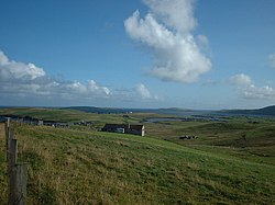
 Aithsetter, with Mousa beyond | |
| Location | |
| Island: | Mainland |
| Grid reference: | HU430301 |
| Location: | 60°3’14"N, 1°13’34"W |
| Data | |
| Post town: | Shetland |
| Postcode: | ZE2 |
| Dialling code: | 01950 |
| Local Government | |
| Council: | Shetland |
| Parliamentary constituency: |
Orkney and Shetland |
Cunningsburgh, formerly also known as Coningsburgh, is a hamlet and ancient parish in the south of Mainland, Shetland. Its name is from the Old Norse Konungsborgr, meaning "King's castle".
The hamlet is on the coast, nine miles south south west of Lerwick, about half way between there and Sumburgh Head, on the A970 road.[1] The parish was merged with Dunrossness and Sandwick.
Amongst the settlements in the old parish is Aithsetter.
Outside links
| ("Wikimedia Commons" has material about Cunningsburgh) |
References
- ↑ "A970". Sabre. http://www.sabre-roads.org.uk/wiki/index.php?title=A970. Retrieved 16 December 2014.
- The Gazetteer of Scotland (Wilson, Rev. John, 1882)