Cossall
From Wikishire
Revision as of 09:42, 11 April 2019 by Owain (Talk | contribs) (Created page with "{{infobox town |county=Nottingham |picture=Cossall village.jpg |picture caption=View towards St Catherine's Church |latitude=52.976 |longitude=-1.281 |population=606 |census y...")
| Cossall | |
| Nottinghamshire | |
|---|---|
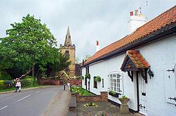
 View towards St Catherine's Church | |
| Location | |
| Grid reference: | SK4842 |
| Location: | 52°58’34"N, 1°16’52"W |
| Data | |
| Population: | 606 (2011) |
| Post town: | Nottingham |
| Postcode: | NG16 |
| Dialling code: | 0115 |
| Local Government | |
| Council: | Broxtowe |
| Parliamentary constituency: |
Broxtowe |
| Website: | Cossall Parish Council |
Cossall is a village and parish in the Broxtow wapentake of Nottinghamshire, a mile east of Ilkeston. The 2001 Census recorded a parish population of 612,[1] reducing slightly to 606 at the 2011 Census.[2] North of the hamlet is a slag heap formed of tons of waste extracted from local coal mines.
References
- ↑ "Area: Cossall CP (Parish)"
- ↑ "Civil Parish population 2011". Neighbourhood Statistics. Office for National statistics. http://www.neighbourhood.statistics.gov.uk/dissemination/LeadKeyFigures.do?a=7&b=11122339&c=Cossall&d=16&e=62&g=6456659&i=1001x1003x1032x1004&m=0&r=1&s=1460035902164&enc=1. Retrieved 7 April 2016.
Further reading
| ("Wikimedia Commons" has material about Cossall) |
- Pevsner, Nikolaus (1951). Nottinghamshire. The Buildings of England. Harmondsworth: Penguin Books. p. 55.