Churchend, Twyning
From Wikishire
Revision as of 18:35, 21 November 2019 by RB (Talk | contribs) (Created page with "{{Infobox town |name=Churchend |county=Gloucestershire |picture=Twyning church - geograph.org.uk - 265945.jpg |picture caption=St Mary Magdalene, Churchend |os grid ref=SO8933...")
| Churchend | |
| Gloucestershire | |
|---|---|
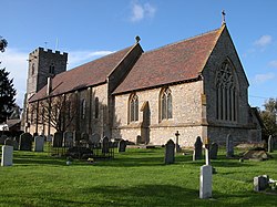
 St Mary Magdalene, Churchend | |
| Location | |
| Grid reference: | SO893360 |
| Location: | 52°1’22"N, 2°9’25"W |
| Data | |
| Postcode: | GL20 |
| Local Government | |
| Council: | South Gloucestershire |
Churchend is a hamlet in the very north of Gloucestershire and which, with its parent village, Twyning, is within a bubble of the county almost cut off from the body of the county and surrounded by Worcestershire. It is two miles north of Tewkesbury, between the River Severn and the Warwickshire Avon.
The hamlet contains Twyning's parish church, St Mary Magdalene, hence the name 'Church End'.
