Chester-le-Street
| Chester-le-Street | |
| County Durham | |
|---|---|
 Front Street | |
| Location | |
| Grid reference: | NZ270512 |
| Location: | 54°51’34"N, 1°34’12"W |
| Data | |
| Population: | 23,946 (2001) |
| Post town: | Chester Le Street |
| Postcode: | DH2, DH3 |
| Dialling code: | 0191 |
| Local Government | |
| Council: | County Durham |
| Parliamentary constituency: |
North Durham |
Chester-le-Street is a town in County Durham of ancient roots. Its history goes back to Roman times when it was called Concangis, and in the later Anglo-Saxon period it became the seat of a bishop for over a century, preceding Durham.
The town is on the River Wear, 7 miles south of Newcastle upon Tyne and miles west of Sunderland. The Parish Church of St Mary and St Cuthbert is where the body of St Cuthbert remained for 112 years before being transferred to Durham Cathedral, and the site of the first translation of the Gospels into English, when Aldred wrote the Old English gloss between the lines of the Lindisfarne Gospels there.[1]
A market town, markets are held on Tuesdays, Fridays and Saturdays.
Contents
Name
The Romans called their fort Concangis or Concagium, a Latinisation of the British name for the area; "Place of the horse people", which also gave name to the waterway through the town, Cong Burn. The precise Roman name is uncertain as it does not appear in Roman records, but Concangis is the assumed name most used today.[2][3]
In Anglo-Saxon times the settlement was called Cuneceastra[4] or Conceastre,[5] the name of the burn combined with the English word for a Roman fort. This shortened over time to Chester, the name still used locally for the town, and in mediaeval Latin records it appears as Cestria.
Since "Chester" is a common name for towns, in the Middle Ages "Street", for the Roman road, was added. The Universal etymological English dictionary of 1749 gives the town as "Chester upon Street" (and describes it as "a Village in the Bishoprick of Durham").[6] At some point this was shortened to the modern form.
History
There is evidence of Iron Age use of the River Wear near the town,[7] but the history of Chester-le-Steet starts with the Roman fort of Concangis. This was built alongside the Roman road, Cade's Road, (now Front Street) and close to the River Wear, around 100 AD, and was occupied until the Romans had retreated from Britain by the early fifth century. At the time the Wear was navigable to at least Concangis, and may also have provided food for the garrisons stationed there.[8]
After the Romans left there is no record of who lived there until 883 when a group of monks, driven out of Lindisfarne seven years earlier, stopped there to build a wooden shrine and church to St Cuthbert, whose body they had borne with them. While they were there the town was the centre of Christianity for much of the northeast, because it was the seat of the Bishop of Lindisfarne, making the church a cathedral. There the monks translated into English the Lindisfarne Gospels, which they had brought with them. They stayed for 112 years, leaving in 995 for the safer and more permanent home at Durham.[9]
The church was rebuilt in stone in 1054, and despite the loss of its bishopric it seems to have retained a degree of wealth and influence. In 1080 most of the huts in the town were burned and many people killed in retaliation for the death of William Walcher, the first Prince-Bishop, at the hands of an English mob.
County Durham is not recorded in the Domesday Book as the king did not rule here directly; the Bishop had jurisdiction.
The route of Cade's Road, the Roman road, was reused by succeeding ages, the Roman work buried under later roads which became the Great North Road, the main route from London and the south to Newcastle upon Tyne and Edinburgh. The town's location on the road played a significant role in its development, as well as its name, as inns sprang up to cater for the travelling trade: both riders and horses needed to rest on journeys usually taking days to complete. This trade reached a peak in the early 19th century as more and more people and new mail services travelled by stagecoach, before falling off with the coming of the railways. The town was bypassed when the A167 was routed around the town, and this was later supplanted by the faster A1(M).[10]
The coal industry also left its mark on the town. From the late 17th century onwards coal was dug in increasing quantities in the region. Mining industry was concentrated by the rivers, for transportation by sea to other parts of the country, and Chester-le-Street was at the centre of the coal being dug and shipped away down the Wear, so a centre of coal related communication and commerce. At the same time the growth of the mines and the influx of miners supported local businesses, not just the many inns but new shops and services, themselves bringing in more people to work in them. These people would later work in new industries established in the town to take advantage of its good communications and access to raw materials.[11]
A striking a tragic episodes in the town's history occurred during the winter of 1811/12, when the miners went on strike.[12] Collieries owned by the Dean and Chapter of Durham Cathedral were brought to a standstill by the strike, causing much hardship amongst the people of the town. On New Year's Day, 1 January 1812, the Bishop of Durham, Shute Barrington, broke the strike in an uncompromising manner as he sent a detachment of soldiers from Durham Castle to force a return to work; it is thought that this act was forced by pressure from the government, concerned that the strike was affecting industrial output at a crucial time for the Napoleonic Wars.
The Jarrow March
On the evening of 5 October 1936 the Jarrow marchers stopped at the town centre after their first day's walk. The church hall was used to house them before they continued onward the following day.[13]
Sights of the town

John Leland described Chester-le-Street in the 1530s as: Chiefly one main street of very mean building in height.
Daniel Defoe echoed the sentiment.
St Mary and St Cuthbert church
St Mary and St Cuthbert church possesses a rare surviving anchorage, one of the best-preserved in the country. It was built for an anchorite, an extreme form of hermit. His or her walled-up cell had only a slit to observe the altar and an opening for food, while outside was an open grave for when the occupant died. It was occupied in turn by six anchorites from 1383 to about 1538, and is now a museum known as the Anker's House.
The north aisle is occupied by a line of Lumley family effigies, only five genuine, assembled circa 1590. Some have been chopped-off to fit and resemble a casualty station at Agincourt, according to Sir Simon Jenkins in his England's Thousand Best Churches. It is Chester-le-Street's only Grade I listed building.[14]
Chester Burn viaduct
The viaduct to the northwest of the town centre was completed in 1868 for the North Eastern Railway, to enable trains to travel at high speed on a more direct route between Newcastle and Durham. It is 800 feet long with 11 arches, now spanning a road and supermarket car-park, and is a Grade II listed building.[15]
Lumley Castle
Lumley Castle sits upon the eastern bank of the River Wear and overlooks the town and the Riverside Park.
Bethel United Reform church
The small United Reformed Church on Low Chare, just off the main Front Street, was built in 1814 as the Bethel Congregational Chapel and remodeled in 1860. It is still in use and is a Grade II listed building.[16]
The Queens Head Hotel
The Queens Head Hotel, locally known as The Queens Head, is located in the central area of the Front Street. It was built over 250 years ago when this road was the main route from Edinburgh and Newcastle to the south and London. It is set back from the street and is still one of the largest buildings in the street and so the town centre, and is a Grade II listed building.[17]
The Post Office
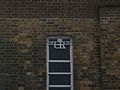
Chester-le-Street Post Office at 137 Front Street is in the Art Deco style and replaced a smaller building located on the corner of Relton Terrace and Ivanhoe Terrace, and was opened in 1936 during the reign of Edward VIII before his abdication. As a result, it is one of only two Post Offices to feature a Royal Emblem of King Edward VIII and a plaque outside recognies this.
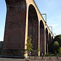
The railway viaduct over Cong Burn
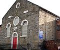
Bethel United Reformed Church, on Low Chare
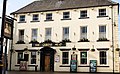
The Queens Head Hotel on Front Street
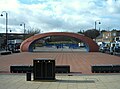
The Civic Heart Sculpture over the market place
Edward VIII Royal Emblem at the main Post Office


Sport
The Emirates Durham International Cricket Ground at Chester-le-Street is home to Durham County Cricket Club which became a first class county in 1992. The town also has its own cricket club
- Cricket:
- Durham County Cricket Club
- Cricket Club
- Rowing: Chester-le-Street Rowing Club, based on the River Wear
Early football
Mediæval football was once played in the town. The game was played annually on Shrove Tuesday between the "Upstreeters" and "Downstreeters". Play started at 1pm and finished at 6pm. To start the game, the ball was thrown from a window in the centre of the town and in one game more than 400 players took part. The centre of the street was the dividing line and the winner was the side where the ball was (Up or Down) at 6pm. It was played from the Middle Ages until 1932, when it was outlawed by the police and people trying to carry on the tradition were arrested.[18][19]
Outside links
| ("Wikimedia Commons" has material about Chester-le-Street) |
- Durham County Cricket Club
- Chester-le-Live community website
- Chester-le-Street Heritage Group local history society
- Chester-le-Street Railway Station
- Chester-le-Street Scout District
- Chester-le-Street shops
- Chester-le-Street Town Football Club
- Concangis Roman fort or castra
References
- ↑ Selkirk (2000) pp. 339–40
- ↑ Selkirk (2001) p. 45
- ↑ Purdon (1992) p. 8
- ↑ Purdon (1992) p. 10
- ↑ Selkirk (2000) p. 337
- ↑ Bailey, Nathan (1749). An universal etymological English dictionary. p. 168. http://books.google.com/books?id=UucIAAAAQAAJ.
- ↑ Purdon (1992) p. 6
- ↑ Selkirk (2000) pp. 45–92
- ↑ Selkirk (2000) pp. 337–40
- ↑ Purdon (1992) p. 16
- ↑ Selkirk (2001) pp. 391–427
- ↑ William Page, The Victorian History of the County of Durham 3 volumes (London, 1907), vol II, p. 153
- ↑ Matt Perry (2005). The Jarrow crusade: protest and legend. p. 31. ISBN 1-873757-60-3. http://books.google.co.uk/books?id=LVKyAAAAIAAJ.
- ↑ "Chester-le-Street, Church of St Mary & St Cuthbert; Listed building (Chester-le-Street)". Durham County Council. http://www.keystothepast.info/K2P.nsf/K2PDetail?readform&PRN=D11004. Retrieved 28 September 2010.
- ↑ "Railway Viaduct Over Chester Burn; Listed building (Chester-le-Street)". Durham County Council. http://www.keystothepast.info/K2P.nsf/K2PDetail?readform&PRN=D11031. Retrieved 28 September 2010.
- ↑ "Chester-le-Street, United Reformed Church; Listed building (Chester-le-Street)". Durham County Council. http://www.keystothepast.info/K2P.nsf/K2PDetail?readform&PRN=D11005. Retrieved 28 September 2010.
- ↑ "Queens Head Hotel; Listed building (Chester-le-Street)". Durham County Council. http://www.keystothepast.info/K2P.nsf/K2PDetail?readform&PRN=D11046. Retrieved 28 September 2010.
- ↑ Purdon (1992) pp. 21–22
- ↑ Shrove Tide Football
Books
- Selkirk, Raymond (2000). Chester-le-Street & Its Place in History. Birtley, County Durham: Casdec Print & Design Centre. ISBN 1-900456-05-2.
- Purdon, Gavin (1992). Chester-le-Street and district – The people and the place.