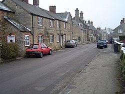
Charlton, Northamptonshire
From Wikishire
Revision as of 19:15, 17 January 2024 by RB (Talk | contribs) (Created page with "{{Infobox town |name=Charlton |county=Northamptonshire |picture=Main Street, Charlton - geograph.org.uk - 99358.jpg |picture caption=Main Street |os grid ref=SP528360 |latitud...")
| Charlton | |
| Northamptonshire | |
|---|---|
 Main Street | |
| Location | |
| Grid reference: | SP528360 |
| Location: | 52°1’12"N, 1°13’55"W |
| Data | |
| Post town: | Banbury |
| Postcode: | OX17 |
| Local Government | |
| Council: | West Northamptonshire |
Charlton is a village near Newbottle in Northamptonshire, sitting between Brackley and Kings Sutton, close to a small tributary of the River Cherwell.
The remains of an Iron Age fort, Rainsborough Camp, lie just to the south of the village.[1]
The lawyer and politician F.E. Smith, 1st Earl of Birkenhead lived on Main Street in the village, in a house called The Cottage.[2] He took as his second peerage title Viscount Furneaux of Charlton, and his ashes are buried in the village cemetery.[3]
Outside links
| ("Wikimedia Commons" has material about Charlton, Northamptonshire) |
References
- ↑ "Newbottle". British History Online. https://www.british-history.ac.uk/rchme/northants/vol4/pp103-108.
- ↑ National Heritage List 1265934: Charlton, Northamptonshire (Grade II listing)
- ↑ The Oxford Dictionary of National Biography, Volume 51. Oxford University Press. 2004. pp. 114–118.