Difference between revisions of "Broadwas"
From Wikishire
(Created page with "{{Infobox town |county=Worcester |latitude=52.194047 |longitude=-2.350335 |population=387 |picture=Little Green, Broadwas.jpg |picture caption=Little Green |LG district=Malver...") |
(No difference)
|
Latest revision as of 18:38, 23 April 2024
| Broadwas | |
| Worcestershire | |
|---|---|
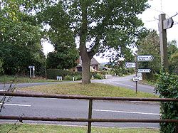
 Little Green | |
| Location | |
| Location: | 52°11’39"N, 2°21’1"W |
| Data | |
| Population: | 387 |
| Post town: | Worcester |
| Postcode: | WR6 |
| Local Government | |
| Council: | Malvern Hills |
| Parliamentary constituency: |
West Worcestershire |
Broadwas, or Broadwas-on-Teme, is a village and parish in the Oswaldslow hundred of Worcestershire. According to the 2021 census it had a population of 387.[1] The village is located on the River Teme, about six miles west of Worcester on the A44 road.
Off the main road near the River Teme is the red sandstone church of St Mary Magdelene.[2]
History
Following the Poor Law Amendment Act 1834 Broadwas Parish ceased to be responsible for maintaining the poor in its parish. This responsibility was transferred to Martley Poor Law Union.[3]
References
- ↑ "Broadwas". https://citypopulation.de/en/uk/westmidlands/admin/malvern_hills/E04010292__broadwas/.
- ↑ Bridges, Tim Churches of Worcestershire 2000 Logaston Press, Herefordshire p28 ISBN 1 904396 39 9
- ↑ Worcestershire Family History Guidebook Morgan, Vanessa 2011, The History Press, Stroud, Gloucestershire.p68
| ("Wikimedia Commons" has material about Broadwas) |