Bridgelands
From Wikishire
Revision as of 17:05, 4 December 2016 by RB (Talk | contribs) (Created page with "{{Infobox town |name=Bridgelands |county 1=Roxburghshire |county 2=Selkirkshire |picture=Sheep at Bridgelands (geograph 3238214).jpg |picture caption=Sheep at Bridgelands |os...")
| Bridgelands | |
| Roxburghshire, Selkirkshire | |
|---|---|
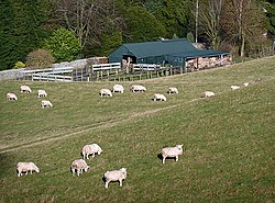
 Sheep at Bridgelands | |
| Location | |
| Grid reference: | NT481304 |
| Location: | 55°33’53"N, 2°49’25"W |
| Data | |
| Postcode: | TD7 |
| Local Government | |
| Council: | Scottish Borders |
| Parliamentary constituency: |
Berwickshire, Roxburgh and Selkirk |
Bridgelands is a village and an 18th-century house on the border of Roxburghshire with Selkirkshire. It is less than a mile and a half from the town centre of Selkirk, at the end of a thin finger of Roxburghshire stretching down toward's its neighbour's county town.
Outside links
| ("Wikimedia Commons" has material about Bridgelands) |
- CANMORE (RCAHMS) record of Bridgelands House
- Old Roads of Scotland: Bridgelands, Teviot
- Border Telegraph, March 2008: "Watch out for the Bridgelands Beast"
This Roxburghshire article is a stub: help to improve Wikishire by building it up.