Battleborough
From Wikishire
| Battleborough | |
| Somerset | |
|---|---|

| |
| Location | |
| Grid reference: | ST344502 |
| Location: | 51°14’52"N, 2°56’26"W |
| Data | |
| Local Government | |
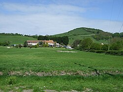
Battleborough is a hamlet at the foot of Brent Knoll in Somerset.
Local legend suggests that the name of the hamlet refers to an ancient battle between Celts and Danes.
This small community comes under the Parish Council of neighbouring Brent Knoll village but is separated from there by fields. It sits along the A38 and consists of 4 homes, including Battleborough Farm a Grade II listed building dating from the 17th century.
Battleborough Lane is the only road in the hamlet and is now cut in half by fields, the other half being in Brent Knoll village itself.