Difference between revisions of "Angle Tarn (Patterdale)"
From Wikishire
(Created page with "Angle Tarn File:Angle tarn (Patterdale) - geograph.org.uk - 632417.jpg|right|thumb|250px|An...") |
(→References) |
||
| Line 11: | Line 11: | ||
==References== | ==References== | ||
{{Reflist}} | {{Reflist}} | ||
| − | *{{wmap|54. | + | |
| − | + | *Location map: {{wmap|54.5194|-2.90056|zoom=14}} | |
[[Category:Lakes of Westmorland]] | [[Category:Lakes of Westmorland]] | ||
Latest revision as of 13:31, 3 February 2016
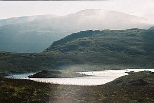
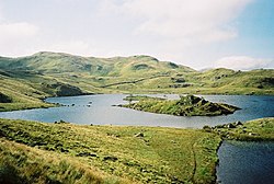
Angle Tarn is a lake in Westmorland, on the Angletarn Pikes about a mile east of Hartsop. Located at an altitude of 1,572 feet, the lake has an area of 15 acres, with a maximum depth of 30 feet.[1]
The tarn has a distinctive shape, resembling a fish hook. It contains two rocky islets and a small broken peninsula.[2]
Outside links
| ("Wikimedia Commons" has material about Angle Tarn (Patterdale)) |
References
- ↑ "Angle Tarn (Patterdale)". f22.org.uk. http://www.f22.org.uk/lakes/Angle_Tarn_Patterdale/index.htm. Retrieved 25 July 2012.
- ↑ Otley, Jonathan (1830). A concise description of the English lakes, and adjacent mountains: with general directions to tourists: notices of the botany, mineralogy, and geology of the district; observations on meteorolgy; the floating island in Derwent lake; and black-lead mine in Borrowdale. The author. p. 32. http://books.google.com/books?id=yHUuAAAAMAAJ&pg=PA32. Retrieved 25 July 2012.
- Location map: 54.5194 -2.90056

