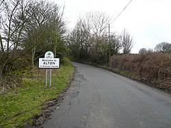
Alton, Derbyshire
From Wikishire
Revision as of 19:36, 4 May 2021 by RB (Talk | contribs) (Created page with "{{Infobox town |name=Alton |county=Derbyshire |picture=Alton Hill - geograph.org.uk - 345504.jpg |picture caption=Alton village |os grid ref=SK361642 |latitude=53.174 |longitu...")
| Alton | |
| Derbyshire | |
|---|---|
 Alton village | |
| Location | |
| Grid reference: | SK361642 |
| Location: | 53°10’26"N, 1°27’36"W |
| Data | |
| Post town: | Chesterfield |
| Postcode: | S42 |
| Local Government | |
| Council: | North East Derbyshire |
Alton is a very small village in Derbyshire, around two miles from Clay Cross although not part of the town.
The village does not have a church, a school or a public house; the nearest public house is in Ashover. Being a rural community, Alton is surrounded by several farms.
Alton also has easy access to local landmark Ashover Rock, or the Fabrick as it is locally known.
Outside links
| ("Wikimedia Commons" has material about Alton, Derbyshire) |