Kilflynn
| Kilflynn Irish: Cill Flainn | |
| County Kerry | |
|---|---|

| |
| Location | |
| Grid reference: | Q895239 |
| Location: | 52°21’2"N, 9°37’31"W |
| Data | |
| Population: | 144 (2022) |
| Local Government | |
| Dáil constituency: |
Kerry |
Kilflynn is a village in the north of County Kerry, seven miles north-east of Tralee, just off the N69 road from Tralee to Listowel.
Name
The name Cill Flainn is of unknown origin, but two main suggestions are commonly circulated. Cill in the Irish language can mean 'cell' or 'churchyard' so in context might mean 'Church of Flainn.' A popularised tale[1][2] is that it was named after a hermit monk, Flainn, said to have lived by the River Shannow (which runs through Kilflynn). Crippled and blind, he was visited by the Virgin Mary, who offered to restore his ailing sight. Flainn declined, asking for the miraculous power to be transferred to others by way of a local well (now 'Tobar Flainn'; 'well or spring of Flainn'). Some refer to this person as ‘St Flainn,’ but no such person was canonised. There is possible confusion with St Flannan, originally from Killaloe in County Clare.[3][4]
The alternative suggestion is that the name derives from the O’Flannan tribe: in August 1931, in the Proceedings of the Royal Irish Academy, a paper referencing a 15th-century manuscript (itself said to be a copy of a 12th-century document) listing rents in Clanmaurice presents both 'O Flannayn' and 'Kyllflanyn' as 'Kilflyn' in the English translation from the original Latin, a significant error which may be the root of the suggestion. The cantred or rural deanery of Othorna & Oflannan (Irish Uí Thorna & Uí Flannáin) was an Anglo-Norman division (which often followed more ancient boundaries) in the realm of the Ciarraighe, and which later became County Kerry some time between 1222 and 1229.[5][6]
Different English spellings appeared over the years. In William Petty's Down Survey of Ireland (1655-1656) the parish appears as 'Kilfloinie Parish'.[7] Charles Smith wrote it as 'Kilflin' in 1756,[8] as did William Wilson 30 years later.[9] In Taylor and Skinner's road maps of 1777[10] it is spelt 'Kilftyn', likely a transcription error.

Samuel Lewis wrote it 'Kilflyn' in 1840[11] and this spelling is extant in places like official Ordnance Survey Ireland maps or on new road signs (particularly the one on Shanow Bridge near Abbeydorney). Locally, and in most documentation, it is spelt 'Kilflynn'.
History
The area became a domain of the Norman lord, Maurice, son of Thomas FitzGerald of Shanid (who died in 1213). Thomas FitzGerald himself was son of Maurice FitzGerald, Lord of Llanstephan, who had supported 'Strongbow', Gilbert de Clare, in his invasion of Ireland in 1169. Later earls of all County Kerry were scions of the FitzMaurice barons.[12][13]


The Stack family, also of Norman heritage, had their seat at Crotto (later known as Crotta) just north of Kilflynn and also owned surrounding townlands. Kilflynn had been known as Stackstown, and the name remains geographically in Stack's Mountains south-east of Kilflynn. The family landowners, namely James (owner of Garrynagore, Gortclohy and Cloghanaleskirt), John (owner of Aghacoora), Richard (owner of Killaspicktarvin (and more northerly townlands)) and Thomas Stack (owner of Gortaneare, Ballyconnell, Castletown, Crotta, Glanballyma, Knocknahila, Cloonnafinneela, and Cappagh)[14] forfeited their landed possessions because of their support for the Irish Rebellion of 1641 and the subsequent Catholic Confederation. The reconquest of Ireland between 1649 and 1652 by Cromwellian forces after the Civil War resulted in the Act for the Settlement of Ireland of 1652 which required a survey for the redistribution of land (hence Sir William Petty's survey) often to invading soldiers in lieu of wages. Henry Ponsonby, the younger brother of Sir John Ponsonby (a colonel of horse in the New Model Army), was the recipient of most of the Stacks' (and others') confiscated land - much of which was profitable. This was reconfirmed in 1666, after the Acts of Settlement.
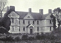
Ponsonby built Crotta House in 1669. The house was sold in 1842 by Thomas Carrique Ponsonby
Kilflynn was on the main road from Tralee to County Limerick. Farming was the principal industry for centuries and services such as forges for smithing, and lime kilns from the late 1600s (to make lime for acidic soils) developed around this. Local forges were still operational in the mid-20th century.
Pictures
| ("Wikimedia Commons" has material about Kilflynn) |
Outside links
References
- ↑ Go Kerry. "Welcome to Kilflynn". http://www.gokerry.ie/locations/kilflynn/.
- ↑ Parker's Pub. "Parker's Pub". http://www.parkerspub.com/kilflynn.htm.
- ↑ "Dec 18th - St.Flannan (7th Century)". http://www.catholicireland.net/saintoftheday/st-flannan/.
- ↑ "Clare People". http://www.clarelibrary.ie/eolas/coclare/people/saint_flannan.htm.
- ↑ MacCotter, Paul. "Lordship and Colony in Anglo-Norman Kerry, 1177-1400". https://www.academia.edu/2058460.
- ↑ Cill Flainn / Kilflynn: Placenames Database of Ireland
- ↑ Petty, William. "The Down Survey of Ireland". http://downsurvey.tcd.ie/down-survey-maps.php#bm=Clanmorris&c=Kerry&indexOfObjectValue=-1&indexOfObjectValueSubstring=-1.
- ↑ Smith, Charles (1756). The Antient and Present State of the County of Kerry. Dublin: Charles Smith. p. 71. https://books.google.com/books?id=9HJbAAAAQAAJ&q=charles+smith+antient+kerry. Retrieved 21 June 2015.
- ↑ Wilson, William (1786). The Post Chaise Companion or Travellers' Directory Through Ireland. Dublin. p. 166. https://archive.org/details/postchaisecompan00wils.
- ↑ Taylor and Skinner. "Maps of the Roads of Ireland Surveyed 1777". open source. https://archive.org/details/TaylorSkinnerMapsOfTheRoadsOfIrelandSurveyed1777.
- ↑ Lewis, Samuel (1840). A Topographical Dictionary of Ireland. London: S.Lewis & Co.. p. 446. https://archive.org/details/b22012333_0002.
- ↑ Curtis, Edmund (1923). (A History of Mediæval Ireland: from 1086 to 1513. Oxford: Routledge. pp. 119, 125. ISBN 978-0-4155-2596-1.
- ↑ Ó Cléirigh, Mícheál; Ó Cléirigh, Cú Choigcríche; Ó Maol Chonaire, Fearfeasa; Ó Duibhgeannáin, Peregrine (1636). Annála Ríoghachta Éireann (The Annals of the Kingdom of Ireland) (2nd, 1856 translation ed.). Dublin: Hodges, Smith & Co.. https://archive.org/stream/annalsofireland00ocle/annalsofireland00ocle_djvu.txt. Retrieved 1 June 2015.
- ↑ The Down Survey of Ireland. "The Down Survey of Ireland: 1641 landowner search". http://downsurvey.tcd.ie/landowners.php#l1=Stacke,+Thomas&l2=Stacke,+James+oge&mc=52.378025,-9.612268&z=11.
